
FCCInfo.com
A Service of Cavell, Mertz & Associates, Inc.
(855) FCC-INFO
|
|
KOHA-LD from 10/31/1996 KOHA-LD from 10/23/1996 KOHA-LD from 02/05/1996 KOHA-LD from 12/01/1995 KOHA-LD from 08/03/1992 |
|
|
||||||||||||||||
|
|
Status: Construction Permit Application Accepted: 09/15/2023 KOHA-LD CP Expires: 09/29/2026 File Number: -0000221058 FCC Website Links: LMS Facility Details This Application Other KOHA-LD Applications Including Superseded Applications Mailing Address Correspondence for KOHA-LD Correspondence related to application -0000221058 Service Contour - Open Street Map or USGS Map (51 dBu) Service Contour - KML / Google Earth (51 dBu) Rabbit Ears Info Search for KOHA-LD Site Location: 41-13-29.6 N 95-57-11.6 W (NAD 83) Site Location: 41-13-29.6 N 95-57-10.5 W (Converted to NAD 27) ERP: 15 kW Polarization: Elliptically polarized Electrical Beam Tilt: 0.5 degrees R/C AGL: 117.3 m (385 ft.) R/C AMSL: 480.3 m (1576 ft.) Emission Mask: Full Service Site Elevation: 363 m. (1191 ft.) Height Overall*: 131 m (430 ft.) (* As Filed In This Application, may differ from ASR Data, Below.) Directional Antenna - Antenna Make/Model: ATC ATC-BCE28M-V3-30 Antenna ID: 1011096 Polarization: Elliptically polarized | ||||||||||||||||||
| Antenna Data for Antenna Id: 1011096 KOHA-LD LD File: -0000221058 ATC - ATC-BCE28M-V3-30 Service: LD Standard Pattern: N Pattern and Field Values Include a 240° Clockwise Rotation | 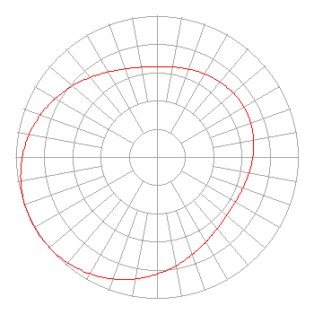 | ||||||||||||||||||
| Azimuth | Ratio | Azimuth | Ratio | Azimuth | Ratio | Azimuth | Ratio | ||||||||||||
| 0 | 0.641 | 10 | 0.647 | 20 | 0.661 | 30 | 0.679 | ||||||||||||
| 40 | 0.694 | 50 | 0.705 | 60 | 0.709 | 70 | 0.705 | ||||||||||||
| 80 | 0.694 | 90 | 0.678 | 100 | 0.661 | 110 | 0.647 | ||||||||||||
| 120 | 0.641 | 130 | 0.645 | 140 | 0.663 | 150 | 0.694 | ||||||||||||
| 160 | 0.734 | 170 | 0.781 | 180 | 0.829 | 190 | 0.876 | ||||||||||||
| 200 | 0.918 | 210 | 0.953 | 220 | 0.979 | 230 | 0.995 | ||||||||||||
| 240 | 1.000 | 250 | 0.995 | 260 | 0.979 | 270 | 0.953 | ||||||||||||
| 280 | 0.918 | 290 | 0.876 | 300 | 0.829 | 310 | 0.781 | ||||||||||||
| 320 | 0.734 | 330 | 0.694 | 340 | 0.663 | 350 | 0.645 | ||||||||||||
Structure Registration Number 1223431 Structure Type: TOWER Registered To: Global Tower, LLC. through American Towers, LLC Structure Address: 2808 "b" Street Omaha, NE County Name: Douglas County ASR Issued: 09/02/2014 Date Built: 03/14/2001 Site Elevation: 363 m (1191 ft.) Structure Height: 121.9 m (400 ft.) Height Overall: 131 m (430 ft.) Overall Height AMSL: 494 m (1621 ft.) FAA Determination: 10/05/2001 FAA Study #: 01-ACE-2153-OE FAA Circular #: 70/7460-1K Paint & Light FAA Chapters: 4, 8, 12 PRIOR STUDY 00-ACE-0423-OE 41-13-29.6 N 95-57-11.6 W (NAD 83) 41-13-29.6 N 95-57-10.5 W (Converted to NAD 27) |
214 N. 7th Street Suite 1 Norfolk, NE 68702 Phone: 402-371-0100 Limited Liability Company | Title: Member Date: 09/15/2023 Application Certifier FLOOD COMMUNICATIONS OF OMAHA, LLC Flood Communications Of Omaha, Llc 214 N. 7th Street Suite 1 Norfolk, NE 68702 Applicant Clarence M Beverage Communications Technologies 23 Binsted Drive Medford, NJ 08055-9561 Broadcast Engineering Consultant Seth L Williams Fletcher, Heald & Hildreth, Plc 1300 N 17th Street 11th Floor Arlington, VA 22209 | |||||||||||||||||