
FCCInfo.com
A Service of Cavell, Mertz & Associates, Inc.
(855) FCC-INFO
|
|
W35DV-D from 02/22/2011 |
|
|
||||||||||||||||
|
|
Status: License Application Accepted: 10/10/2023 License Expires: 04/01/2029 File Number: -0000222336 FCC Website Links: LMS Facility Details This Application Other W35DV-D Applications Including Superseded Applications Mailing Address Correspondence for W35DV-D Correspondence related to application -0000222336 Service Contour - Open Street Map or USGS Map (51 dBu) Service Contour - KML / Google Earth (51 dBu) Rabbit Ears Info Search for W35DV-D Site Location: 33-36-09.7 N 81-46-46.1 W (NAD 83) Site Location: 33-36-09.2 N 81-46-46.7 W (Converted to NAD 27) ERP: 4 kW Polarization: Horizontally polarized Electrical Beam Tilt: 1 degree R/C AGL: 42.7 m (140 ft.) R/C AMSL: 194.5 m (638 ft.) Emission Mask: Full Service Site Elevation: 151.8 m. (498 ft.) Height Overall*: 89.9 m (295 ft.) (* As Filed In This Application, may differ from ASR Data, Below.) Directional Antenna - Antenna Make/Model: Dielectric DLP-4B Antenna ID: 1010865 Polarization: Horizontally polarized
| ||||||||||||||||||
| Antenna Data for Antenna Id: 1010865 W35DV-D LD File: -0000222336 Dielectric - DLP-4B Service: LD Standard Pattern: Y Pattern and Field Values Include a 40° Clockwise Rotation | 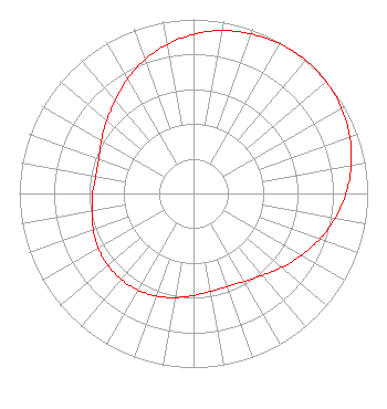 | ||||||||||||||||||
| Azimuth | Ratio | Azimuth | Ratio | Azimuth | Ratio | Azimuth | Ratio | ||||||||||||
| 0 | 0.914 | 10 | 0.951 | 20 | 0.975 | 30 | 0.993 | ||||||||||||
| 40 | 1.000 | 50 | 0.996 | 60 | 0.981 | 70 | 0.955 | ||||||||||||
| 80 | 0.920 | 90 | 0.876 | 100 | 0.826 | 110 | 0.771 | ||||||||||||
| 120 | 0.714 | 130 | 0.661 | 140 | 0.615 | 150 | 0.583 | ||||||||||||
| 160 | 0.569 | 170 | 0.571 | 180 | 0.586 | 190 | 0.607 | ||||||||||||
| 200 | 0.627 | 210 | 0.640 | 220 | 0.645 | 230 | 0.641 | ||||||||||||
| 240 | 0.631 | 250 | 0.613 | 260 | 0.592 | 270 | 0.579 | ||||||||||||
| 280 | 0.570 | 290 | 0.579 | 300 | 0.610 | 310 | 0.650 | ||||||||||||
| 320 | 0.699 | 330 | 0.759 | 340 | 0.817 | 350 | 0.869 | ||||||||||||
Structure Registration Number 1286309 Structure Type: GTOWER Registered To: Verizon Wireless of the East LP Structure Address: 261 Washboard Rd. Aiken, SC County Name: Aiken County ASR Issued: 12/12/2016 Date Built: 02/28/2013 Site Elevation: 151.8 m (498 ft.) Structure Height: 85.3 m (280 ft.) Height Overall: 89.9 m (295 ft.) Overall Height AMSL: 241.7 m (793 ft.) FAA Determination: 08/22/2012 FAA Study #: 2012-ASO-7990-OE FAA Circular #: 70/7460-1K Paint & Light FAA Chapters: 4, 8, 12 Removed expiration date from determination. Scenario 1./jjs/case#635066 33-36-09.7 N 81-46-46.1 W (NAD 83) 33-36-09.2 N 81-46-46.7 W (Converted to NAD 27) |
4370 Peachtree Road, Ne Atlanta, GA 30319 Phone: 202-750-1585 Limited Liability Company | Title: Assistant Secretary Date: 10/10/2023 Application Certifier Gray Television Licensee, Llc 4370 Peachtree Road, Ne Atlanta, GA 30319 Applicant Joan Stewart Wiley Rein Llp 2050 M Street, Nw Washington, DC 20036 | |||||||||||||||||