
FCCInfo.com
A Service of Cavell, Mertz & Associates, Inc.
(855) FCC-INFO
|
|
KMWE-LD from 02/22/2011 |
|
|
||||||||||||||||
|
|
Status: License Application Accepted: 11/27/2023 License Expires: 04/01/2030 File Number: -0000227877 FCC Website Links: LMS Facility Details This Application Other KMWE-LD Applications Including Superseded Applications Mailing Address Correspondence for KMWE-LD Correspondence related to application -0000227877 Service Contour - Open Street Map or USGS Map (51 dBu) Service Contour - KML / Google Earth (51 dBu) Rabbit Ears Info Search for KMWE-LD Site Location: 44-56-47.0 N 93-05-28.5 W (NAD 83) Site Location: 44-56-47.1 N 93-05-27.7 W (Converted to NAD 27) ERP: 15 kW Polarization: Elliptically polarized Electrical Beam Tilt: 1.25 degrees R/C AGL: 128.2 m (421 ft.) R/C AMSL: 359.5 m (1179 ft.) Emission Mask: Full Service Site Elevation: 231.3 m. (759 ft.) Height Overall*: 156.1 m (512 ft.) (* As Filed In This Application, may differ from ASR Data, Below.) Directional Antenna - Antenna Make/Model: ATC C1R Antenna ID: 1011280 Polarization: Elliptically polarized | ||||||||||||||||||
| Antenna Data for Antenna Id: 1011280 KMWE-LD LD File: -0000227877 ATC - C1R Service: LD Standard Pattern: N Pattern and Field Values Include a 275° Clockwise Rotation | 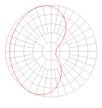 | ||||||||||||||||||
| Azimuth | Ratio | Azimuth | Ratio | Azimuth | Ratio | Azimuth | Ratio | ||||||||||||
| 5 | 0.943 | 15 | 0.859 | 25 | 0.733 | 35 | 0.561 | ||||||||||||
| 45 | 0.377 | 55 | 0.200 | 65 | 0.128 | 75 | 0.118 | ||||||||||||
| 85 | 0.115 | 95 | 0.110 | 105 | 0.115 | 115 | 0.118 | ||||||||||||
| 125 | 0.124 | 135 | 0.185 | 145 | 0.354 | 155 | 0.538 | ||||||||||||
| 165 | 0.681 | 175 | 0.838 | 185 | 0.929 | 195 | 0.981 | ||||||||||||
| 205 | 1.000 | 215 | 0.990 | 225 | 0.966 | 235 | 0.939 | ||||||||||||
| 245 | 0.919 | 255 | 0.907 | 265 | 0.901 | 275 | 0.899 | ||||||||||||
| 285 | 0.900 | 295 | 0.904 | 305 | 0.916 | 315 | 0.935 | ||||||||||||
| 325 | 0.961 | 335 | 0.986 | 345 | 1.000 | 355 | 0.988 | ||||||||||||
Structure Registration Number 1218256 Structure Type: BTWR Registered To: First Bank Building, LLC Structure Address: 332 Minnesota Street St. Paul, MN County Name: Ramsey County ASR Issued: 08/01/2023 Date Built: 12/21/1931 Site Elevation: 231.3 m (759 ft.) Structure Height: 121.9 m (400 ft.) Height Overall: 156.1 m (512 ft.) Overall Height AMSL: 387.4 m (1271 ft.) FAA Determination: 12/20/2022 FAA Study #: 2022-AGL-23018-OE Paint & Light FAA Chapters: 3, 4, 13, 21 Continue As Is OM&L = RED LIGHTS 44-56-47.0 N 93-05-28.5 W (NAD 83) 44-56-47.1 N 93-05-27.7 W (Converted to NAD 27) |
888c 8th Avenue Suite 733 New York, NY 10019 Phone: 212-580-1349 Limited Liability Company | Title: Member Date: 11/27/2023 Application Certifier Sagamorehill Of Minneapolis, Llc 888c 8th Avenue Suite 733 New York, NY 10019 Applicant Clarence M Beverage Communications Technologies 23 Binsted Drive Medford, NJ 08055 Broadcast Engineering Consultant Aaron P Shainis Shainis & Peltzman, Chartered 1850 M Street Nw Suite 240 Washington, DC 20036 Legal Counsel | |||||||||||||||||