
FCCInfo.com
A Service of Cavell, Mertz & Associates, Inc.
(855) FCC-INFO
|
|
K26PF-D from 02/22/2011 |
|
|
||||||||||||||||
|
|
Status: Construction Permit (Licensed And Silent) Application Accepted: 11/16/2023 K26PF-D CP Expires: 03/11/2025 File Number: -0000226660 FCC Website Links: LMS Facility Details This Application Other K26PF-D Applications Including Superseded Applications Mailing Address Correspondence for K26PF-D Correspondence related to application -0000226660 Service Contour - Open Street Map or USGS Map (51 dBu) Service Contour - KML / Google Earth (51 dBu) Rabbit Ears Info Search for K26PF-D Site Location: 45-34-20.5 N 94-21-02.3 W (NAD 83) Site Location: 45-34-20.6 N 94-21-01.3 W (Converted to NAD 27) ERP: 15 kW Polarization: Elliptically polarized Electrical Beam Tilt: 0.5 degrees R/C AGL: 89.9 m (295 ft.) R/C AMSL: 456.3 m (1497 ft.) Emission Mask: Full Service Site Elevation: 366.4 m. (1202 ft.) Height Overall*: 99 m (325 ft.) (* As Filed In This Application, may differ from ASR Data, Below.) Directional Antenna - Antenna Make/Model: Alive Telecom ATC-BCE28CW-V2-26 Antenna ID: 1011265 Polarization: Elliptically polarized | ||||||||||||||||||
| Antenna Data for Antenna Id: 1011265 K26PF-D LD File: -0000226660 Alive Telecom - ATC-BCE28CW-V2-26 Service: LD Standard Pattern: N | 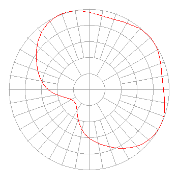 | ||||||||||||||||||
| Azimuth | Ratio | Azimuth | Ratio | Azimuth | Ratio | Azimuth | Ratio | ||||||||||||
| 0 | 0.959 | 10 | 0.929 | 20 | 0.925 | 30 | 0.951 | ||||||||||||
| 40 | 0.985 | 50 | 1.000 | 60 | 0.985 | 70 | 0.951 | ||||||||||||
| 80 | 0.925 | 90 | 0.929 | 100 | 0.959 | 110 | 0.990 | ||||||||||||
| 120 | 0.997 | 130 | 0.975 | 140 | 0.922 | 150 | 0.845 | ||||||||||||
| 160 | 0.758 | 170 | 0.680 | 180 | 0.605 | 190 | 0.510 | ||||||||||||
| 200 | 0.397 | 210 | 0.302 | 220 | 0.253 | 230 | 0.241 | ||||||||||||
| 240 | 0.253 | 250 | 0.302 | 260 | 0.397 | 270 | 0.510 | ||||||||||||
| 280 | 0.605 | 290 | 0.680 | 300 | 0.758 | 310 | 0.845 | ||||||||||||
| 320 | 0.922 | 330 | 0.975 | 340 | 0.997 | 350 | 0.990 | ||||||||||||
Structure Registration Number 1210568 Structure Type: TOWER Registered To: SpectraSite Communications, LLC. through American Towers, LLC. Structure Address: 30999 115 Th. Ave. (305807) St. Joseph, MN County Name: Stearns County ASR Issued: 01/16/2013 Date Built: 04/01/1999 Site Elevation: 366.4 m (1202 ft.) Structure Height: 91.4 m (300 ft.) Height Overall: 99 m (325 ft.) Overall Height AMSL: 465.4 m (1527 ft.) FAA Determination: 11/22/2011 FAA Study #: 2011-AGL-6820-OE FAA Circular #: 70/7460-1J Paint & Light FAA Chapters: 4, 8, 13 PRIOR STUDY 2006-AGL-9277-OE 45-34-20.5 N 94-21-02.3 W (NAD 83) 45-34-20.6 N 94-21-01.3 W (Converted to NAD 27) |
38955 Hills Tech Dr. Farmington Hills, MI 48331 Phone: 248-536-0776 Limited Liability Company | Title: Ceo Date: 11/16/2023 Application Certifier Bridge News Llc 38955 Hills Tech Dr. Farmington Hills, MI 48331 Applicant Erik C Swanson, PE Hatfield & Dawson 9500 Greenwood Ave N Seattle, WA 98103 Consulting Engineer Dan J Alpert The Law Office Of Dan J. Alpert 2120 21st Rd. N Arlington, VA 22201 Legal Counsel | |||||||||||||||||