
FCCInfo.com
A Service of Cavell, Mertz & Associates, Inc.
(855) FCC-INFO
|
|
KJTV-TV from 08/16/1985 KJTV-TV from 11/16/1981 |
Virtual Channel 34 |  |
|
|||||||||||||||||||||
|
|
Repacking Information: No changes Status: Application Application Accepted: 01/12/2024 License Expires: 08/01/2022 File Number: -0000235333 FCC Website Links: LMS Facility Details This Application Other KJTV-TV Applications Including Superseded Applications Mailing Address Correspondence for KJTV-TV Correspondence related to application -0000235333 Service Contour - Open Street Map or USGS Map (41 dBu) Service Contour - KML / Google Earth (41 dBu) Public Inspection Files Rabbit Ears Info Search for KJTV-TV Site Location: 33-30-08.3 N 101-52-21.3 W (NAD 83) Site Location: 33-30-08.0 N 101-52-19.7 W (Converted to NAD 27) ERP: 200 kW Polarization: Horizontally polarized HAAT: 282.1 m (926 ft.) Electrical Beam Tilt: 0.7 degrees R/C AGL: 286.2 m (939 ft.) R/C AMSL: 1263.7 m (4146 ft.) Site Elevation: 977.5 m. (3207 ft.) Height Overall*: 297.2 m (975 ft.) (* As Filed In This Application, may differ from ASR Data, Below.) Directional Antenna - Antenna Make/Model: R.F. Systems PHPR64U3313 Antenna ID: 1005101 Polarization: Horizontally polarized
| ||||||||||||||||||||||||
| Antenna Data for Antenna Id: 1005101 KJTV-TV DT File: -0000235333 R.F. Systems - PHPR64U3313 Service: DT Standard Pattern: Y | 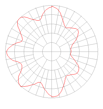 | ||||||||||||||||||||||||
| Azimuth | Ratio | Azimuth | Ratio | Azimuth | Ratio | Azimuth | Ratio | ||||||||||||||||||
| 0 | 0.963 | 2 | 0.967 | 10 | 0.896 | 20 | 0.716 | ||||||||||||||||||
| 30 | 0.605 | 40 | 0.664 | 50 | 0.733 | 60 | 0.651 | ||||||||||||||||||
| 70 | 0.500 | 80 | 0.427 | 90 | 0.425 | 100 | 0.418 | ||||||||||||||||||
| 110 | 0.525 | 120 | 0.679 | 130 | 0.723 | 140 | 0.654 | ||||||||||||||||||
| 150 | 0.624 | 160 | 0.773 | 170 | 0.939 | 177 | 0.975 | ||||||||||||||||||
| 180 | 0.961 | 190 | 0.832 | 200 | 0.709 | 210 | 0.828 | ||||||||||||||||||
| 220 | 0.977 | 222 | 1.000 | 230 | 0.935 | 240 | 0.739 | ||||||||||||||||||
| 250 | 0.719 | 260 | 0.898 | 270 | 0.967 | 280 | 0.841 | ||||||||||||||||||
| 290 | 0.676 | 300 | 0.767 | 310 | 0.956 | 315 | 0.990 | ||||||||||||||||||
| 320 | 0.968 | 330 | 0.797 | 340 | 0.727 | 350 | 0.876 | ||||||||||||||||||
Structure Registration Number 1248244 Structure Type: GTOWER Registered To: FLP Ramar, Ltd. Structure Address: 100th & University Lubbock, TX County Name: Lubbock County ASR Issued: 10/27/2017 Date Built: 12/08/2006 Site Elevation: 977.5 m (3207 ft.) Structure Height: 295.7 m (970 ft.) Height Overall: 297.2 m (975 ft.) Overall Height AMSL: 1274.7 m (4182 ft.) FAA Determination: 08/02/2017 FAA Study #: 2017-ASW-7973-OE FAA Circular #: 70/7460-1K Paint & Light FAA Chapters: 4, 9, 12 PRIOR STUDY 2007-ASW-3651-OE 33-30-08.3 N 101-52-21.3 W (NAD 83) 33-30-08.0 N 101-52-19.7 W (Converted to NAD 27) |
525 Blackburn Drive Augusta, GA 30907 Phone: 706-922-5644 Limited Liability Company | Title: Officer Date: 01/12/2024 Application Certifier Sagamorehill Of Lubbock, Llc 525 Blackburn Drive Augusta, GA 30907 Applicant Joseph M. Davis, P.E. Chesapeake Rf Consultants, Llc 207 Old Dominion Road Yorktown, VA 23692 Consulting Engineer Scott Woodworth Edinger Associates Pllc 1725 I Street, Nw, Suite 300 Washington, DC 20006 | |||||||||||||||||||||||
|
| ||||||||||||||||||||||||