
FCCInfo.com
A Service of Cavell, Mertz & Associates, Inc.
(855) FCC-INFO
|
|
WTWV from 04/05/1996 |
Virtual Channel 14 |
|
||||||||||||||||
|
|
WTWV is a channel sharing host for WWTW, Senatobia, Mississippi Repacking Information: No changes Status: STA – Special Temporary Authority Application Accepted: 02/05/2024 STA Expires: 08/12/2024 File Number: -0000238235 FCC Website Links: LMS Facility Details This Application Other WTWV Applications Including Superseded Applications Mailing Address Correspondence for WTWV Correspondence related to application -0000238235 Service Contour - Open Street Map or USGS Map (41 dBu) Service Contour - KML / Google Earth (41 dBu) Public Inspection Files Rabbit Ears Info Search for WTWV Site Location: 35-12-34.3 N 89-49-01.4 W (NAD 83) Site Location: 35-12-34.0 N 89-49-01.1 W (Converted to NAD 27) ERP: 1000 kW Polarization: Elliptically polarized HAAT: 261 m (856 ft.) Electrical Beam Tilt: 0.75 degrees R/C AGL: 265 m (869 ft.) R/C AMSL: 349.4 m (1146 ft.) Site Elevation: 84.4 m. (277 ft.) Height Overall*: 275.8 m (905 ft.) (* As Filed In This Application, may differ from ASR Data, Below.) Directional Antenna - Antenna Make/Model: DIELECTRIC TFU-30GTH/VP-R 6T130 Antenna ID: 91069 Polarization: Elliptically polarized | ||||||||||||||||||
| Antenna Data for Antenna Id: 91069 WTWV DT File: -0000238235 DIELECTRIC - TFU-30GTH/VP-R 6T130 Service: DT Standard Pattern: Y | 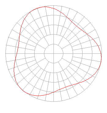 | ||||||||||||||||||
| Azimuth | Ratio | Azimuth | Ratio | Azimuth | Ratio | Azimuth | Ratio | ||||||||||||
| 0 | 0.935 | 10 | 0.871 | 20 | 0.807 | 30 | 0.761 | ||||||||||||
| 40 | 0.745 | 50 | 0.761 | 60 | 0.807 | 70 | 0.871 | ||||||||||||
| 80 | 0.935 | 90 | 0.982 | 100 | 1.000 | 110 | 0.982 | ||||||||||||
| 120 | 0.935 | 130 | 0.871 | 140 | 0.807 | 150 | 0.761 | ||||||||||||
| 160 | 0.745 | 170 | 0.761 | 180 | 0.807 | 190 | 0.871 | ||||||||||||
| 200 | 0.935 | 210 | 0.982 | 220 | 1.000 | 230 | 0.982 | ||||||||||||
| 240 | 0.935 | 250 | 0.871 | 260 | 0.807 | 270 | 0.761 | ||||||||||||
| 280 | 0.745 | 290 | 0.761 | 300 | 0.807 | 310 | 0.871 | ||||||||||||
| 320 | 0.935 | 330 | 0.982 | 340 | 1.000 | 350 | 0.982 | ||||||||||||
Structure Registration Number 1249321 Structure Type: Registered To: RADIANT LIFE MINISTRIES. INC. Structure Address: 3145 Bartlett Corp Drive Bartlett, TN County Name: Shelby County ASR Issued: 06/10/2021 Date Built: 04/01/2008 Site Elevation: 84.4 m (277 ft.) Structure Height: 274.3 m (900 ft.) Height Overall: 275.8 m (905 ft.) Overall Height AMSL: 360.2 m (1182 ft.) FAA Determination: 04/19/2005 FAA Study #: 2005-ASO-139-OE FAA Circular #: 70/7460-1K Paint & Light FAA Chapters: 3, 4, 5, 12 Removed expiration and final dates from determination. Scenario 2./jjs/case#635066 35-12-34.3 N 89-49-01.4 W (NAD 83) 35-12-34.0 N 89-49-01.1 W (Converted to NAD 27) |
7401 Yale Road Bartlett, TN 38133 Phone: 618-997-4700 Not-for-Profit | Title: Chief Business Officer Date: 02/05/2024 Application Certifier Faith Community Television, Inc. 7401 Yale Road Bartlett, TN 38133 Applicant Joseph C Chautin, III Hardy, Carey, Chautin & Balkin, Llp 1080 W. Causeway Approach Mandeville, LA 70471 Attorney at Law | |||||||||||||||||