
FCCInfo.com
A Service of Cavell, Mertz & Associates, Inc.
(855) FCC-INFO
|
|
WEFG-LD from 01/27/2010 WEFG-LD from 03/16/2007 |
|
|
||||||||||||||||
|
|
Status: Application (Licensed And Silent) Application Accepted: 03/04/2024 License Expires: 02/11/2022 File Number: -0000240358 FCC Website Links: LMS Facility Details This Application Other WEFG-LD Applications Including Superseded Applications Mailing Address Correspondence for WEFG-LD Correspondence related to application -0000240358 Service Contour - Open Street Map or USGS Map (51 dBu) Service Contour - KML / Google Earth (51 dBu) Rabbit Ears Info Search for WEFG-LD Site Location: 40-04-24.0 N 75-11-27.0 W (NAD 83) Site Location: 40-04-23.6 N 75-11-28.4 W (Converted to NAD 27) ERP: 15 kW Polarization: Circularly polarized R/C AGL: 78.3 m (257 ft.) R/C AMSL: 185 m (607 ft.) Emission Mask: Full Service Site Elevation: 106.7 m. (350 ft.) Height Overall*: 88.3 m (290 ft.) (* As Filed In This Application, may differ from ASR Data, Below.) Directional Antenna - Antenna Make/Model: Systems With Reliability Inc. LP16EC Custom Antenna ID: 1011535 Polarization: Circularly polarized | ||||||||||||||||||
| Antenna Data for Antenna Id: 1011535 WEFG-LD LD File: -0000240358 Systems With Reliability Inc. - LP16EC Custom Service: LD Standard Pattern: N Pattern and Field Values Include a 150° Clockwise Rotation | 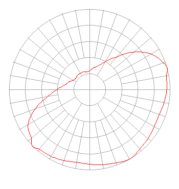 | ||||||||||||||||||
| Azimuth | Ratio | Azimuth | Ratio | Azimuth | Ratio | Azimuth | Ratio | ||||||||||||
| 0 | 0.230 | 10 | 0.270 | 20 | 0.310 | 30 | 0.400 | ||||||||||||
| 40 | 0.530 | 50 | 0.720 | 60 | 0.880 | 70 | 0.970 | ||||||||||||
| 75 | 1.000 | 80 | 0.970 | 90 | 0.960 | 100 | 0.940 | ||||||||||||
| 110 | 0.920 | 120 | 0.930 | 130 | 0.950 | 140 | 0.970 | ||||||||||||
| 150 | 1.000 | 160 | 0.970 | 170 | 0.950 | 180 | 0.930 | ||||||||||||
| 190 | 0.920 | 200 | 0.940 | 210 | 0.960 | 220 | 0.970 | ||||||||||||
| 225 | 1.000 | 230 | 0.940 | 240 | 0.880 | 250 | 0.720 | ||||||||||||
| 260 | 0.530 | 270 | 0.400 | 280 | 0.310 | 290 | 0.270 | ||||||||||||
| 300 | 0.230 | 310 | 0.220 | 320 | 0.230 | 330 | 0.230 | ||||||||||||
| 340 | 0.230 | 350 | 0.220 | ||||||||||||||||
Structure Registration Number 1060096 Structure Type: B Registered To: MORGAN TOWER, INC. Structure Address: 7600 Stenton Avenue Philadelphia, PA County Name: Philadelphia County ASR Issued: 06/07/2007 Date Built: 01/01/1985 Site Elevation: 106.7 m (350 ft.) Structure Height: 88.3 m (290 ft.) Height Overall: 88.3 m (290 ft.) Overall Height AMSL: 195 m (640 ft.) FAA Determination: 05/09/2007 FAA Study #: 2007-AEA-1530-OE FAA Circular #: 70/7460-1K Paint & Light FAA Chapters: 4, 8, 12 PRIOR STUDY 2003-AEA-1173-OE 40-04-24.0 N 75-11-27.0 W (NAD 83) 40-04-23.6 N 75-11-28.4 W (Converted to NAD 27) |
2 Johns Lane Lafayette Hill, PA 19444 Phone: 267-784-1007 Corporation | Title: Manager Date: 03/04/2024 Application Certifier Philadelphia Television Network, Inc. Philadelphia Television Network, Inc. 2 Johns Lane Lafayette Hill, PA 19444 Applicant Richard Goetz R & L Media Systems 135 N Country Club Dr Hendersonville, TN 37075 Broadcast Consultant Jeffrey L. Timmons, Esq. Jeffrey L. Timmons, Esq. 974 Branford Lane Nw Lilburn, GA 30047 FCC Counsel | |||||||||||||||||