
FCCInfo.com
A Service of Cavell, Mertz & Associates, Inc.
(855) FCC-INFO
|
|
|
Post-repack Channel 2 Virtual Channel 16 |
|
|||||||||||||||||||||||||
|
|
Repacking Information: Pre-Repack Channel: 16 Post-Repack Channel: 2 Post-Repack ERP: 4.01 kW Phase: 5 Completion Deadline: 9/11/2019 Upstream/Downstream Dependencies Other Linked Stations Find nearby TV Facilities Status: Construction Permit Application Accepted: 03/14/2024 WGGS-TV CP Expires: 03/27/2027 File Number: -0000240900 FCC Website Links: LMS Facility Details This Application Other WGGS-TV Applications Including Superseded Applications Mailing Address Correspondence for WGGS-TV Correspondence related to application -0000240900 Service Contour - Open Street Map or USGS Map (41 dBu) Service Contour - KML / Google Earth (41 dBu) Public Inspection Files History Cards for WGGS-TV Rabbit Ears Info Search for WGGS-TV DTS Site Number: 2 Site Location: 34-18-46.8 N 82-56-25.5 W (NAD 83) Site Location: 34-18-46.4 N 82-56-26.0 W (Converted to NAD 27) ERP: 3 kW Polarization: Horizontally polarized HAAT: 81.1 m (266 ft.) R/C AGL: 57.7 m (189 ft.) R/C AMSL: 300 m (984 ft.) Site Elevation: 242.3 m. (795 ft.) Height Overall*: 118.6 m (389 ft.) (* As Filed In This Application, may differ from ASR Data, Below.) Directional Antenna - Antenna Make/Model: Dielectric TUA-TU-02/04L-T FCC Antenna ID: 1011560 Polarization: Horizontally polarized
| |||||||||||||||||||||||||||
| Antenna Data for Antenna Id: 1011560 WGGS-TV DD File: -0000240900 Dielectric - TUA-TU-02/04L-T FCC Service: DD Standard Pattern: N | 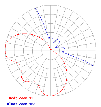 | |||||||||||||||||||||||||||
| Azimuth | Ratio | Azimuth | Ratio | Azimuth | Ratio | Azimuth | Ratio | |||||||||||||||||||||
| 0 | 0.032 | 10 | 0.026 | 20 | 0.019 | 30 | 0.027 | |||||||||||||||||||||
| 40 | 0.032 | 50 | 0.024 | 60 | 0.012 | 70 | 0.023 | |||||||||||||||||||||
| 80 | 0.031 | 90 | 0.032 | 100 | 0.031 | 110 | 0.104 | |||||||||||||||||||||
| 120 | 0.216 | 130 | 0.370 | 140 | 0.544 | 150 | 0.716 | |||||||||||||||||||||
| 160 | 0.857 | 170 | 0.953 | 180 | 0.995 | 190 | 0.954 | |||||||||||||||||||||
| 200 | 0.799 | 210 | 0.769 | 220 | 0.878 | 230 | 0.849 | |||||||||||||||||||||
| 240 | 0.727 | 250 | 0.784 | 260 | 0.955 | 270 | 0.999 | |||||||||||||||||||||
| 272 | 1.000 | 280 | 0.982 | 290 | 0.884 | 300 | 0.732 | |||||||||||||||||||||
| 310 | 0.551 | 320 | 0.373 | 330 | 0.218 | 340 | 0.105 | |||||||||||||||||||||
| 350 | 0.031 | |||||||||||||||||||||||||||
Structure Registration Number 1018778 Structure Type: GTOWER Registered To: Georgia Public Telecommunications Commission Structure Address: 2.5 Mi S Of Hartwell Ga East Adjacent To The Hart County Solid Waste Dept Hartwell, GA County Name: Hart County ASR Issued: 01/05/2024 Date Built: 10/22/2020 Site Elevation: 242.3 m (795 ft.) Structure Height: 118.6 m (389 ft.) Height Overall: 118.6 m (389 ft.) Overall Height AMSL: 360.9 m (1184 ft.) FAA Determination: 11/21/2023 FAA Study #: 2023-ASO-29261-OE FAA Circular #: 70/7460-1M Paint & Light FAA Chapters: 4, 8, 15 34-18-46.8 N 82-56-25.5 W (NAD 83) 34-18-46.4 N 82-56-26.0 W (Converted to NAD 27) |
Greenville, SC 29602 Phone: 864-244-1616 Corporation | Title: President Date: 03/14/2024 Application Certifier Carolina Christian Broadcasting, Inc. Greenville, SC 29602 Applicant Joseph C. Chautin, III Hardy, Carey, Chautin & Balkin, Llp 1080 West Causeway Approach Mandeville, LA 70471 Legal Counsel | ||||||||||||||||||||||||||
| ||||||||||||||||||||||||||||