
FCCInfo.com
A Service of Cavell, Mertz & Associates, Inc.
(855) FCC-INFO
|
|
|
Post-repack Channel 2 Virtual Channel 16 |
|
|||||||||||||||||||||||||
|
|
Repacking Information: Pre-Repack Channel: 16 Post-Repack Channel: 2 Post-Repack ERP: 4.01 kW Phase: 5 Completion Deadline: 9/11/2019 Upstream/Downstream Dependencies Other Linked Stations Find nearby TV Facilities Status: Construction Permit Application Accepted: 03/14/2024 WGGS-TV CP Expires: 03/27/2027 File Number: -0000240900 FCC Website Links: LMS Facility Details This Application Other WGGS-TV Applications Including Superseded Applications Mailing Address Correspondence for WGGS-TV Correspondence related to application -0000240900 Service Contour - Open Street Map or USGS Map (41 dBu) Service Contour - KML / Google Earth (41 dBu) Public Inspection Files History Cards for WGGS-TV Rabbit Ears Info Search for WGGS-TV DTS Site Number: 3 Site Location: 34-36-35.7 N 83-22-14.3 W (NAD 83) Site Location: 34-36-35.3 N 83-22-14.7 W (Converted to NAD 27) ERP: 0.2 kW Polarization: Horizontally polarized HAAT: 98.9 m (324 ft.) R/C AGL: 20 m (66 ft.) R/C AMSL: 454.3 m (1490 ft.) Site Elevation: 434.3 m. (1425 ft.) Height Overall*: 184.1 m (604 ft.) (* As Filed In This Application, may differ from ASR Data, Below.) Directional Antenna - Antenna Make/Model: Dielectric TUA-C1A Antenna ID: 1011558 Polarization: Horizontally polarized
| |||||||||||||||||||||||||||
| Antenna Data for Antenna Id: 1011558 WGGS-TV DD File: -0000240900 Dielectric - TUA-C1A Service: DD Standard Pattern: N | 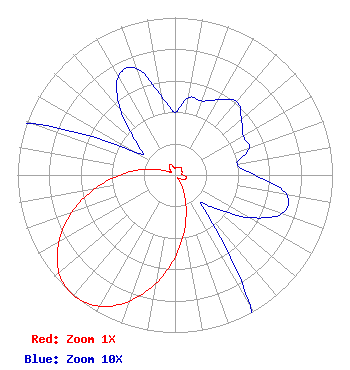 | |||||||||||||||||||||||||||
| Azimuth | Ratio | Azimuth | Ratio | Azimuth | Ratio | Azimuth | Ratio | |||||||||||||||||||||
| 0 | 0.040 | 10 | 0.050 | 20 | 0.050 | 30 | 0.055 | |||||||||||||||||||||
| 40 | 0.061 | 50 | 0.055 | 60 | 0.050 | 70 | 0.050 | |||||||||||||||||||||
| 80 | 0.040 | 90 | 0.051 | 100 | 0.072 | 110 | 0.072 | |||||||||||||||||||||
| 120 | 0.054 | 130 | 0.032 | 140 | 0.029 | 150 | 0.096 | |||||||||||||||||||||
| 160 | 0.202 | 170 | 0.351 | 180 | 0.523 | 190 | 0.698 | |||||||||||||||||||||
| 200 | 0.852 | 210 | 0.962 | 220 | 1.000 | 230 | 0.962 | |||||||||||||||||||||
| 240 | 0.852 | 250 | 0.698 | 260 | 0.523 | 270 | 0.351 | |||||||||||||||||||||
| 280 | 0.202 | 290 | 0.096 | 300 | 0.029 | 310 | 0.032 | |||||||||||||||||||||
| 320 | 0.054 | 330 | 0.072 | 340 | 0.072 | 350 | 0.051 | |||||||||||||||||||||
Structure Registration Number 1018908 Structure Type: GTOWER Registered To: Marquee Broadcasting Georgia, Inc. Structure Address: Approx 200' Nne Of Sr 17 & 490 Ft Of The Sr 17 & Bend N Hickory Rd Intersection. Toccoa, GA County Name: Stephens County ASR Issued: 07/01/2015 Date Built: 01/01/1983 Site Elevation: 434.3 m (1425 ft.) Structure Height: 168.6 m (553 ft.) Height Overall: 184.1 m (604 ft.) Overall Height AMSL: 618.4 m (2029 ft.) FAA Determination: 10/17/2012 FAA Study #: 2012-ASO-8110-OE FAA Circular #: 70/7460-1K Paint & Light FAA Chapters: 3, 4, 5, 12 34-36-35.7 N 83-22-14.3 W (NAD 83) 34-36-35.3 N 83-22-14.7 W (Converted to NAD 27) |
Greenville, SC 29602 Phone: 864-244-1616 Corporation | Title: President Date: 03/14/2024 Application Certifier Carolina Christian Broadcasting, Inc. Greenville, SC 29602 Applicant Joseph C. Chautin, III Hardy, Carey, Chautin & Balkin, Llp 1080 West Causeway Approach Mandeville, LA 70471 Legal Counsel | ||||||||||||||||||||||||||
| ||||||||||||||||||||||||||||