
FCCInfo.com
A Service of Cavell, Mertz & Associates, Inc.
(855) FCC-INFO
|
|
K32OI-D from 06/28/2019 K32OI-D from 06/02/2010 |
|
|
||||||||||||||||
|
|
Status: License Application Accepted: 07/07/2021 License Expires: 12/01/2022 File Number: -0000151887 FCC Website Links: LMS Facility Details This Application Other K32OI-D Applications Including Superseded Applications Mailing Address Correspondence for K32OI-D Correspondence related to application -0000151887 Service Contour - Open Street Map or USGS Map (51 dBu) Service Contour - KML / Google Earth (51 dBu) Rabbit Ears Info Search for K32OI-D Site Location: 40-43-41.9 N 123-58-21.5 W (NAD 83) Site Location: 40-43-42.4 N 123-58-17.3 W (Converted to NAD 27) ERP: 0.1 kW Polarization: Horizontally polarized R/C AGL: 6 m (20 ft.) R/C AMSL: 811.3 m (2662 ft.) Emission Mask: Full Service Site Elevation: 805.3 m. (2642 ft.) Height Overall*: 135.3 m (444 ft.) (* As Filed In This Application, may differ from ASR Data, Below.) Directional Antenna - Antenna Make/Model: Scala CL-1469 Antenna ID: 20778 Polarization: Horizontally polarized | ||||||||||||||||||
| Antenna Data for Antenna Id: 20778 K32OI-D LD File: -0000151887 Scala - CL-1469 Service: LD Standard Pattern: Y Pattern and Field Values Include a 290° Clockwise Rotation | 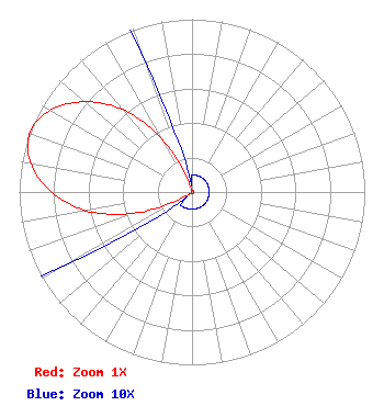 | ||||||||||||||||||
| Azimuth | Ratio | Azimuth | Ratio | Azimuth | Ratio | Azimuth | Ratio | ||||||||||||
| 0 | 0.010 | 10 | 0.010 | 20 | 0.010 | 30 | 0.010 | ||||||||||||
| 40 | 0.010 | 50 | 0.010 | 60 | 0.010 | 70 | 0.010 | ||||||||||||
| 80 | 0.010 | 90 | 0.010 | 100 | 0.010 | 110 | 0.010 | ||||||||||||
| 120 | 0.010 | 130 | 0.010 | 140 | 0.010 | 150 | 0.010 | ||||||||||||
| 160 | 0.010 | 170 | 0.010 | 180 | 0.010 | 190 | 0.010 | ||||||||||||
| 200 | 0.010 | 210 | 0.010 | 220 | 0.010 | 230 | 0.010 | ||||||||||||
| 240 | 0.086 | 250 | 0.361 | 260 | 0.622 | 270 | 0.812 | ||||||||||||
| 280 | 0.947 | 290 | 1.000 | 300 | 0.947 | 310 | 0.812 | ||||||||||||
| 320 | 0.622 | 330 | 0.361 | 340 | 0.086 | 350 | 0.010 | ||||||||||||
Structure Registration Number 1224088 Structure Type: GTOWER Registered To: Redwood Empire Public Television Inc Structure Address: 1603 Barry Road Kneeland, CA County Name: Humboldt County ASR Issued: 12/29/2016 Date Built: 10/23/2015 Site Elevation: 805.3 m (2642 ft.) Structure Height: 121.9 m (400 ft.) Height Overall: 135.3 m (444 ft.) Overall Height AMSL: 940.6 m (3086 ft.) FAA Determination: 12/21/2016 FAA Study #: 2016-AWP-12398-OE FAA Circular #: 70/7460-1L Paint & Light FAA Chapters: 4, 8, 12 PRIOR STUDY 2015-AWP-9887-OE 40-43-41.9 N 123-58-21.5 W (NAD 83) 40-43-42.4 N 123-58-17.3 W (Converted to NAD 27) |
Hurst, TX 76054 Phone: 214-770-7770 Corporation | Title: Ceo Date: 07/07/2021 Application Certifier EDGE SPECTRUM, INC. Edge Spectrum, Inc. Hurst, TX 76054 Applicant Susan Hansen B. W. St. Clair 2305 Vida Shaw Rd. New Iberia, LA 70563 Consultant Randy Weiss Edge Spectrum, Inc. Hurst, TX 76054 CEO Caleb Weiss Ark Multicasting, Inc. Cedar Hill, TX 75106 President | |||||||||||||||||