
FCCInfo.com
A Service of Cavell, Mertz & Associates, Inc.
(855) FCC-INFO
|
|
K17FE-D from 01/21/2003 K17FE-D from 09/10/1980 |
|
|
||||||||||||||||
|
|
Status: License Application Accepted: 07/12/2021 License Expires: 04/01/2022 File Number: -0000152352 FCC Website Links: LMS Facility Details This Application Other K17FE-D Applications Including Superseded Applications Mailing Address Correspondence for K17FE-D Correspondence related to application -0000152352 Service Contour - Open Street Map or USGS Map (51 dBu) Service Contour - KML / Google Earth (51 dBu) Rabbit Ears Info Search for K17FE-D Site Location: 46-23-23.0 N 95-04-04.0 W (NAD 83) Site Location: 46-23-23.1 N 95-04-02.9 W (Converted to NAD 27) ERP: 15 kW Polarization: Horizontally polarized R/C AGL: 144 m (472 ft.) R/C AMSL: 555.5 m (1823 ft.) Emission Mask: Stringent Site Elevation: 411.5 m. (1350 ft.) Height Overall*: 150.9 m (495 ft.) (* As Filed In This Application, may differ from ASR Data, Below.) Directional Antenna - Antenna Make/Model: Antenna Concepts Inc. ACS16A Antenna ID: 17722 Polarization: Horizontally polarized | ||||||||||||||||||
| Antenna Data for Antenna Id: 17722 K17FE-D LD File: -0000152352 Antenna Concepts Inc. - ACS16A Service: LD Standard Pattern: Y | 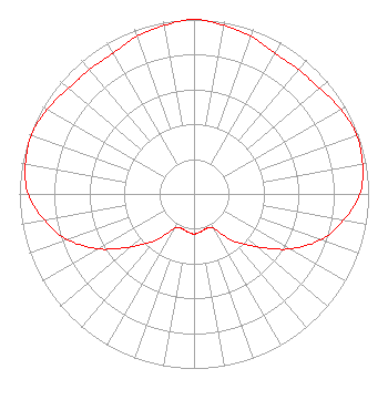 | ||||||||||||||||||
| Azimuth | Ratio | Azimuth | Ratio | Azimuth | Ratio | Azimuth | Ratio | ||||||||||||
| 0 | 1.000 | 10 | 0.980 | 20 | 0.960 | 30 | 0.930 | ||||||||||||
| 40 | 0.930 | 50 | 0.940 | 60 | 0.970 | 70 | 0.990 | ||||||||||||
| 80 | 0.980 | 90 | 0.950 | 100 | 0.870 | 110 | 0.770 | ||||||||||||
| 120 | 0.630 | 130 | 0.470 | 140 | 0.350 | 150 | 0.230 | ||||||||||||
| 160 | 0.210 | 170 | 0.220 | 180 | 0.230 | 190 | 0.220 | ||||||||||||
| 200 | 0.210 | 210 | 0.230 | 220 | 0.350 | 230 | 0.470 | ||||||||||||
| 240 | 0.630 | 250 | 0.770 | 260 | 0.870 | 270 | 0.950 | ||||||||||||
| 280 | 0.980 | 290 | 0.990 | 300 | 0.970 | 310 | 0.940 | ||||||||||||
| 320 | 0.930 | 330 | 0.930 | 340 | 0.960 | 350 | 0.980 | ||||||||||||
Structure Registration Number 1031884 Structure Type: TOWER Registered To: KSAX-TV, INC. Structure Address: 3.0 Mi. Wsw Of Verndale Wadena, MN County Name: Wadena County ASR Issued: 07/17/2007 Date Built: 09/01/1981 Site Elevation: 411.5 m (1350 ft.) Structure Height: 139.8 m (459 ft.) Height Overall: 150.9 m (495 ft.) Overall Height AMSL: 562.4 m (1845 ft.) FAA Determination: 08/25/1997 FAA Study #: 97-AGL-3610-OE FAA Circular #: 70/7460-1J Paint & Light FAA Chapters: 3, 4, 5, 13 46-23-23.0 N 95-04-04.0 W (NAD 83) 46-23-23.1 N 95-04-02.9 W (Converted to NAD 27) |
3415 University Ave. St. Paul, MN 55114 Phone: 651-642-4334 Limited Liability Company | Title: Vice President Date: 07/12/2021 Application Certifier KSAX-TV, INC. Ksax-tv, Inc. 3415 University Ave., West St. Paul, MN 55114 Applicant Louis R duTreil, Jr Dutreil Lundin & Rackley Inc 5120 Station Way Sarasota, FL 34233 Technical Consultant CHARLES R. NAFTALIN, ESQ Holland & Knight Llp 800 17th Street, N.w. Suite #1100 Washington, DC 20006 | |||||||||||||||||