
FCCInfo.com
A Service of Cavell, Mertz & Associates, Inc.
(855) FCC-INFO
|
|
KMAX-TV from 01/11/1995 KMAX-TV from 04/02/1981 KMAX-TV from 09/17/1979 |
Post-repack Channel 24 Virtual Channel 31 |
|
|||||||||||||||||||||||||||||||||||||||||||||||||
|
|
Repacking Information: Pre-Repack Channel: 21 Post-Repack Channel: 24 Post-Repack ERP: 910 kW Phase: 9 Completion Deadline: 5/1/2020 Upstream/Downstream Dependencies Other Linked Stations Find nearby TV Facilities Status: License Application Accepted: 09/24/2021 License Expires: 12/01/2022 File Number: -0000160347 FCC Website Links: LMS Facility Details This Application Other KMAX-TV Applications Including Superseded Applications Mailing Address Correspondence for KMAX-TV Correspondence related to application -0000160347 Service Contour - Open Street Map or USGS Map (41 dBu) Service Contour - KML / Google Earth (41 dBu) Public Inspection Files History Cards for KMAX-TV Rabbit Ears Info Search for KMAX-TV Site Location: 38-14-50.0 N 121-30-07.0 W (NAD 83) Site Location: 38-14-50.3 N 121-30-03.2 W (Converted to NAD 27) ERP: 388.6 kW Polarization: Elliptically polarized HAAT: 435 m (1427 ft.) Electrical Beam Tilt: 0.75 degrees R/C AGL: 437.8 m (1436 ft.) R/C AMSL: 437.8 m (1436 ft.) Calculated Site Elevation: 0 m. Height Overall*: 472.1 m (1549 ft.) (* As Filed In This Application, may differ from ASR Data, Below.) Directional Antenna - Antenna Make/Model: Jampro JSH-25/D21 TEO WITH JSH-24/D25 TEO Antenna ID: 94279 Polarization: Elliptically polarized | |||||||||||||||||||||||||||||||||||||||||||||||||||
| Antenna Data for Antenna Id: 94279 KMAX-TV DX File: -0000160347 Jampro - JSH-25/D21 TEO WITH JSH-24/D25 TEO Service: DX Standard Pattern: Y | 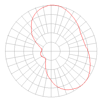 | |||||||||||||||||||||||||||||||||||||||||||||||||||
| Azimuth | Ratio | Azimuth | Ratio | Azimuth | Ratio | Azimuth | Ratio | |||||||||||||||||||||||||||||||||||||||||||||
| 0 | 1.000 | 10 | 0.996 | 20 | 0.954 | 30 | 0.895 | |||||||||||||||||||||||||||||||||||||||||||||
| 40 | 0.845 | 50 | 0.795 | 60 | 0.749 | 70 | 0.741 | |||||||||||||||||||||||||||||||||||||||||||||
| 80 | 0.755 | 90 | 0.805 | 100 | 0.855 | 110 | 0.906 | |||||||||||||||||||||||||||||||||||||||||||||
| 120 | 0.964 | 130 | 1.000 | 140 | 0.996 | 150 | 0.954 | |||||||||||||||||||||||||||||||||||||||||||||
| 160 | 0.890 | 170 | 0.785 | 180 | 0.637 | 190 | 0.504 | |||||||||||||||||||||||||||||||||||||||||||||
| 200 | 0.348 | 210 | 0.236 | 220 | 0.201 | 230 | 0.212 | |||||||||||||||||||||||||||||||||||||||||||||
| 240 | 0.231 | 250 | 0.239 | 260 | 0.228 | 270 | 0.209 | |||||||||||||||||||||||||||||||||||||||||||||
| 280 | 0.204 | 290 | 0.252 | 300 | 0.376 | 310 | 0.533 | |||||||||||||||||||||||||||||||||||||||||||||
| 320 | 0.665 | 330 | 0.810 | 340 | 0.906 | 350 | 0.964 | |||||||||||||||||||||||||||||||||||||||||||||
Structure Registration Number 1012855 Structure Type: GTOWER Registered To: Transtower, Inc. Structure Address: 14003 River Rd .7 Mi Ne Walnut Grove, CA County Name: Sacramento County ASR Issued: 02/22/2018 Date Built: 08/15/2014 Structure Height: 438.3 m (1438 ft.) Height Overall: 472.1 m (1549 ft.) Overall Height AMSL: 472.1 m (1549 ft.) FAA Determination: 03/10/2014 FAA Study #: 2014-AWP-1382-OE FAA Circular #: 70/7460-1K Paint & Light FAA Chapters: 3, 4, 5, 12 The FAA approves the Bird Lighting Deviation on the tower with this FAA Study. PRIOR STUDY 2009-AWP-5529-OE 38-14-50.0 N 121-30-07.0 W (NAD 83) 38-14-50.3 N 121-30-03.2 W (Converted to NAD 27) |
2020 M. St., Nw - Licensing Dept Washington, DC 20036 Phone: 202-457-4505 Corporation | Title: Vp, Government Relations And Regulatory Date: 09/24/2021 Application Certifier SACRAMENTO TELEVISION STATIONS, INC Sacramento Television Stations, Inc 2020 M. St., Nw - Licensing Dept Washington, DC 20036 Applicant Joseph M. Davis, P.E. Chesapeake Rf Consultants, Llc 207 Old Dominion Road Yorktown, VA 23692 Consulting Engineer Daniel G. Ryson Viacomcbs 2020 M. St., Nw - Licensing Dept Washington, DC 20036 Director Spectrum Management | ||||||||||||||||||||||||||||||||||||||||||||||||||
|
| |||||||||||||||||||||||||||||||||||||||||||||||||||