
FCCInfo.com
A Service of Cavell, Mertz & Associates, Inc.
(855) FCC-INFO
|
|
WQAV-CD from 05/08/2014 WQAV-CD from 10/17/2013 |
Post-repack Channel 26 |
|
||||||||||||||||
|
|
Repacking Information: Pre-Repack Channel: 50 Post-Repack Channel: 26 Post-Repack ERP: 9.38 kW Phase: 4 Completion Deadline: 8/2/2019 Upstream/Downstream Dependencies Other Linked Stations Find nearby TV Facilities Status: License Application Accepted: 10/03/2022 License Expires: 06/01/2023 File Number: -0000201734 FCC Website Links: LMS Facility Details This Application Other WLPH-CD Applications Including Superseded Applications Mailing Address Correspondence for WLPH-CD Correspondence related to application -0000201734 Service Contour - Open Street Map or USGS Map (51 dBu) Service Contour - KML / Google Earth (51 dBu) Public Inspection Files Rabbit Ears Info Search for WLPH-CD Site Location: 40-02-19.7 N 75-14-12.8 W (NAD 83) Site Location: 40-02-19.3 N 75-14-14.2 W (Converted to NAD 27) ERP: 15 kW Polarization: Elliptically polarized Electrical Beam Tilt: 1.5 degrees R/C AGL: 194.8 m (639 ft.) R/C AMSL: 270.4 m (887 ft.) Emission Mask: Full Service Site Elevation: 75.6 m. (248 ft.) Height Overall*: 360.5 m (1183 ft.) (* As Filed In This Application, may differ from ASR Data, Below.) Directional Antenna - Antenna Make/Model: DIELECTRIC TLP-6W/VP Antenna ID: 1010123 Polarization: Elliptically polarized | ||||||||||||||||||
| Antenna Data for Antenna Id: 1010123 WLPH-CD DC File: -0000201734 DIELECTRIC - TLP-6W/VP Service: DC Standard Pattern: N | 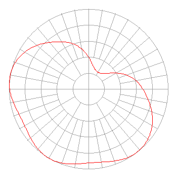 | ||||||||||||||||||
| Azimuth | Ratio | Azimuth | Ratio | Azimuth | Ratio | Azimuth | Ratio | ||||||||||||
| 0 | 0.397 | 10 | 0.302 | 20 | 0.253 | 30 | 0.241 | ||||||||||||
| 40 | 0.253 | 50 | 0.302 | 60 | 0.397 | 70 | 0.510 | ||||||||||||
| 80 | 0.605 | 90 | 0.680 | 100 | 0.758 | 110 | 0.845 | ||||||||||||
| 120 | 0.922 | 130 | 0.975 | 140 | 0.997 | 150 | 0.990 | ||||||||||||
| 160 | 0.959 | 170 | 0.929 | 180 | 0.925 | 190 | 0.951 | ||||||||||||
| 200 | 0.985 | 210 | 1.000 | 220 | 0.985 | 230 | 0.951 | ||||||||||||
| 240 | 0.925 | 250 | 0.929 | 260 | 0.959 | 270 | 0.990 | ||||||||||||
| 280 | 0.997 | 290 | 0.975 | 300 | 0.922 | 310 | 0.845 | ||||||||||||
| 320 | 0.758 | 330 | 0.680 | 340 | 0.605 | 350 | 0.510 | ||||||||||||
Structure Registration Number 1026755 Structure Type: GTOWER Registered To: American Towers LLC Structure Address: 216 Paoli Ave (010110) Philadelphia, PA County Name: Philadelphia County ASR Issued: 06/09/2015 Date Built: 08/01/2008 Site Elevation: 75.6 m (248 ft.) Structure Height: 338.9 m (1112 ft.) Height Overall: 360.5 m (1183 ft.) Overall Height AMSL: 436.1 m (1431 ft.) FAA Determination: 04/23/2015 FAA Study #: 2015-AEA-640-OE FAA Circular #: 70/7460-1K Paint & Light FAA Chapters: 3, 4, 5, 12 PRIOR STUDY 2013-AEA-5467-OE 40-02-19.7 N 75-14-12.8 W (NAD 83) 40-02-19.3 N 75-14-14.2 W (Converted to NAD 27) |
813 N. Fenwick Street Allentown, PA 18109 Phone: 610-351-8259 Not-for-Profit | Title: Manager Date: 10/03/2022 Application Certifier Wmt, Llc 5670 Wilshire Boulevard, Suite 1620 Los Angeles, CA 90036 Applicant LAWRENCE ROGOW Wmt, Llc 5670 Wilshire Boulevard, Suite 1620 Los Angeles, CA 90036 MANAGER JOAN STEWART Wiley Rein Llp 2050 M Street Nw Washington, DC 20036 | |||||||||||||||||