
FCCInfo.com
A Service of Cavell, Mertz & Associates, Inc.
(855) FCC-INFO
|
|
WQAV-CD from 05/08/2014 WQAV-CD from 10/17/2013 |
Post-repack Channel 26 |
|
||||||||||||||||
|
|
Repacking Information: Pre-Repack Channel: 50 Post-Repack Channel: 26 Post-Repack ERP: 9.38 kW Phase: 4 Completion Deadline: 8/2/2019 Upstream/Downstream Dependencies Other Linked Stations Find nearby TV Facilities Status: License Application Accepted: 12/20/2022 License Expires: 06/01/2023 File Number: -0000205727 FCC Website Links: LMS Facility Details This Application Other WLPH-CD Applications Including Superseded Applications Mailing Address Correspondence for WLPH-CD Correspondence related to application -0000205727 Service Contour - Open Street Map or USGS Map (51 dBu) Service Contour - KML / Google Earth (51 dBu) Public Inspection Files Rabbit Ears Info Search for WLPH-CD Site Location: 40-02-19.7 N 75-14-12.8 W (NAD 83) Site Location: 40-02-19.3 N 75-14-14.2 W (Converted to NAD 27) ERP: 15 kW Polarization: Elliptically polarized Electrical Beam Tilt: 1.5 degrees R/C AGL: 194.8 m (639 ft.) R/C AMSL: 270.4 m (887 ft.) Emission Mask: Full Service Site Elevation: 75.6 m. (248 ft.) Height Overall*: 360.5 m (1183 ft.) (* As Filed In This Application, may differ from ASR Data, Below.) Directional Antenna - Antenna Make/Model: DIELECTRIC TLP-6W/VP Antenna ID: 1010123 Polarization: Elliptically polarized | ||||||||||||||||||
| Antenna Data for Antenna Id: 1010123 WLPH-CD DC File: -0000205727 DIELECTRIC - TLP-6W/VP Service: DC Standard Pattern: N | 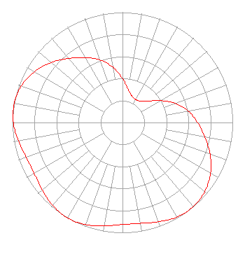 | ||||||||||||||||||
| Azimuth | Ratio | Azimuth | Ratio | Azimuth | Ratio | Azimuth | Ratio | ||||||||||||
| 0 | 0.397 | 10 | 0.302 | 20 | 0.253 | 30 | 0.241 | ||||||||||||
| 40 | 0.253 | 50 | 0.302 | 60 | 0.397 | 70 | 0.510 | ||||||||||||
| 80 | 0.605 | 90 | 0.680 | 100 | 0.758 | 110 | 0.845 | ||||||||||||
| 120 | 0.922 | 130 | 0.975 | 140 | 0.997 | 150 | 0.990 | ||||||||||||
| 160 | 0.959 | 170 | 0.929 | 180 | 0.925 | 190 | 0.951 | ||||||||||||
| 200 | 0.985 | 210 | 1.000 | 220 | 0.985 | 230 | 0.951 | ||||||||||||
| 240 | 0.925 | 250 | 0.929 | 260 | 0.959 | 270 | 0.990 | ||||||||||||
| 280 | 0.997 | 290 | 0.975 | 300 | 0.922 | 310 | 0.845 | ||||||||||||
| 320 | 0.758 | 330 | 0.680 | 340 | 0.605 | 350 | 0.510 | ||||||||||||
Structure Registration Number 1026755 Structure Type: GTOWER Registered To: American Towers LLC Structure Address: 216 Paoli Ave (010110) Philadelphia, PA County Name: Philadelphia County ASR Issued: 06/09/2015 Date Built: 08/01/2008 Site Elevation: 75.6 m (248 ft.) Structure Height: 338.9 m (1112 ft.) Height Overall: 360.5 m (1183 ft.) Overall Height AMSL: 436.1 m (1431 ft.) FAA Determination: 04/23/2015 FAA Study #: 2015-AEA-640-OE FAA Circular #: 70/7460-1K Paint & Light FAA Chapters: 3, 4, 5, 12 PRIOR STUDY 2013-AEA-5467-OE 40-02-19.7 N 75-14-12.8 W (NAD 83) 40-02-19.3 N 75-14-14.2 W (Converted to NAD 27) |
813 N. Fenwick Street Allentown, PA 18109 Phone: 610-351-8259 Not-for-Profit | Title: President Date: 12/20/2022 Application Certifier Lighthouse Support 813 N. Fenwick Street Allentown, PA 18109 Applicant Joseph C Chautin, III Hardy, Carey, Chautin & Balkin, Llp 1080 West Causeway Approach Mandeville, LA 70471 Attorney-at-law | |||||||||||||||||