
FCCInfo.com
A Service of Cavell, Mertz & Associates, Inc.
(855) FCC-INFO
|
|
K35PH-D from 08/04/2020 |
|
|
||||||||||||||||
|
|
Status: Construction Permit Application Accepted: 02/13/2023 K35PH-D CP Expires: 08/03/2023 File Number: -0000210687 FCC Website Links: LMS Facility Details This Application Other K35PH-D Applications Including Superseded Applications Mailing Address Correspondence for K35PH-D Correspondence related to application -0000210687 Service Contour - Open Street Map or USGS Map (51 dBu) Service Contour - KML / Google Earth (51 dBu) Rabbit Ears Info Search for K35PH-D Site Location: 30-38-35.0 N 96-19-53.0 W (NAD 83) Site Location: 30-38-34.3 N 96-19-52.1 W (Converted to NAD 27) ERP: 0.2 kW Polarization: Horizontally polarized R/C AGL: 15 m (49 ft.) R/C AMSL: 103 m (338 ft.) Emission Mask: Simple Site Elevation: 88 m. (289 ft.) Height Overall*: 111 m (364 ft.) (* As Filed In This Application, may differ from ASR Data, Below.) Directional Antenna - Antenna Make/Model: Sam SAMCO160 Antenna ID: 1009817 Polarization: Horizontally polarized | ||||||||||||||||||
| Antenna Data for Antenna Id: 1009817 K35PH-D LD File: -0000210687 Sam - SAMCO160 Service: LD Standard Pattern: Y Pattern and Field Values Include a 270° Clockwise Rotation | 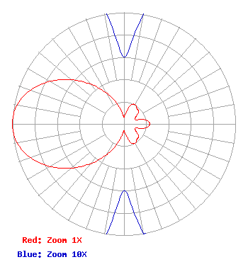 | ||||||||||||||||||
| Azimuth | Ratio | Azimuth | Ratio | Azimuth | Ratio | Azimuth | Ratio | ||||||||||||
| 0 | 0.060 | 10 | 0.100 | 20 | 0.180 | 30 | 0.200 | ||||||||||||
| 40 | 0.180 | 50 | 0.170 | 60 | 0.120 | 70 | 0.110 | ||||||||||||
| 80 | 0.200 | 90 | 0.230 | 100 | 0.200 | 110 | 0.110 | ||||||||||||
| 120 | 0.120 | 130 | 0.170 | 140 | 0.180 | 150 | 0.200 | ||||||||||||
| 160 | 0.180 | 170 | 0.100 | 180 | 0.060 | 190 | 0.108 | ||||||||||||
| 200 | 0.208 | 210 | 0.325 | 220 | 0.465 | 230 | 0.617 | ||||||||||||
| 240 | 0.764 | 250 | 0.888 | 260 | 0.973 | 270 | 1.000 | ||||||||||||
| 280 | 0.973 | 290 | 0.888 | 300 | 0.764 | 310 | 0.617 | ||||||||||||
| 320 | 0.465 | 330 | 0.325 | 340 | 0.208 | 350 | 0.108 | ||||||||||||
Structure Registration Number 1062866 Structure Type: TOWER Registered To: Gray Media Group, Inc. Structure Address: 4141 E 29th St Bryan, TX County Name: Brazos County ASR Issued: 09/09/2020 Date Built: 01/01/1988 Site Elevation: 88 m (289 ft.) Structure Height: 109.7 m (360 ft.) Height Overall: 111 m (364 ft.) Overall Height AMSL: 199 m (653 ft.) FAA Determination: 09/07/2004 FAA Study #: 2004-ASW-4872-OE FAA Circular #: 70/7460-1K Paint & Light FAA Chapters: 4, 8, 12 PRIOR STUDY 2004-ASW-4871-OE 30-38-35.0 N 96-19-53.0 W (NAD 83) 30-38-34.3 N 96-19-52.1 W (Converted to NAD 27) |
9925 Haynes Bridge Rd Suite 200-155 Alpharetta, GA 30022 Phone: 470-413-1820 Limited Liability Company | Title: Member/manager Date: 02/13/2023 Application Certifier Castrelli Media Llc 5174 Mcginnis Ferry Road Suite133 Alpharetta, GA 30005 Applicant Vincent Castelli Castrelli Media Llc 5174 Mcginnis Ferry Road Suite133 Alpharetta, GA 30005 PhD | |||||||||||||||||