
FCCInfo.com
A Service of Cavell, Mertz & Associates, Inc.
(855) FCC-INFO
|
|
K19MW-D from 03/11/2020 |
|
|
||||||||||||||||
|
|
Status: License Application Accepted: 03/10/2023 License Expires: 08/01/2029 File Number: -0000212357 FCC Website Links: LMS Facility Details This Application Other W19EW-D Applications Including Superseded Applications Mailing Address Correspondence for W19EW-D Correspondence related to application -0000212357 Service Contour - Open Street Map or USGS Map (51 dBu) Service Contour - KML / Google Earth (51 dBu) Rabbit Ears Info Search for W19EW-D Site Location: 37-59-18.9 N 87-35-41.1 W (NAD 83) Site Location: 37-59-18.7 N 87-35-41.0 W (Converted to NAD 27) ERP: 0.2 kW Polarization: Horizontally polarized R/C AGL: 10.4 m (34 ft.) R/C AMSL: 146 m (479 ft.) Emission Mask: Simple Site Elevation: 135.6 m. (445 ft.) Height Overall*: 118.5 m (389 ft.) (* As Filed In This Application, may differ from ASR Data, Below.) Directional Antenna - Antenna Make/Model: Sam SAMCO160 Antenna ID: 1009817 Polarization: Horizontally polarized | ||||||||||||||||||
| Antenna Data for Antenna Id: 1009817 W19EW-D LD File: -0000212357 Sam - SAMCO160 Service: LD Standard Pattern: Y Pattern and Field Values Include a 90° Clockwise Rotation | 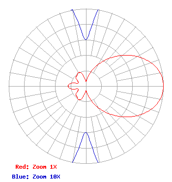 | ||||||||||||||||||
| Azimuth | Ratio | Azimuth | Ratio | Azimuth | Ratio | Azimuth | Ratio | ||||||||||||
| 0 | 0.060 | 10 | 0.108 | 20 | 0.208 | 30 | 0.325 | ||||||||||||
| 40 | 0.465 | 50 | 0.617 | 60 | 0.764 | 70 | 0.888 | ||||||||||||
| 80 | 0.973 | 90 | 1.000 | 100 | 0.973 | 110 | 0.888 | ||||||||||||
| 120 | 0.764 | 130 | 0.617 | 140 | 0.465 | 150 | 0.325 | ||||||||||||
| 160 | 0.208 | 170 | 0.108 | 180 | 0.060 | 190 | 0.100 | ||||||||||||
| 200 | 0.180 | 210 | 0.200 | 220 | 0.180 | 230 | 0.170 | ||||||||||||
| 240 | 0.120 | 250 | 0.110 | 260 | 0.200 | 270 | 0.230 | ||||||||||||
| 280 | 0.200 | 290 | 0.110 | 300 | 0.120 | 310 | 0.170 | ||||||||||||
| 320 | 0.180 | 330 | 0.200 | 340 | 0.180 | 350 | 0.100 | ||||||||||||
Structure Registration Number 1030625 Structure Type: GTOWER Registered To: Gray Media Group, Inc. Structure Address: 1115 Mount Auburn Rd Evansville, IN County Name: Vanderburgh County ASR Issued: 02/11/2019 Date Built: 01/03/2013 Site Elevation: 135.6 m (445 ft.) Structure Height: 117.6 m (386 ft.) Height Overall: 118.5 m (389 ft.) Overall Height AMSL: 254.1 m (834 ft.) FAA Determination: 11/23/2012 FAA Study #: 2012-AGL-8830-OE Paint & Light FAA Chapters: 1, 3, 12, 21 Continue As Is OM&L = PAINT/RED LIGHTS 37-59-18.9 N 87-35-41.1 W (NAD 83) 37-59-18.7 N 87-35-41.0 W (Converted to NAD 27) |
9925 Haynes Bridge Rd Suite 200-155 Alpharetta, GA 30022 Phone: 470-413-1820 Limited Liability Company | Title: Member/manager Date: 03/10/2023 Application Certifier Castelli Media, Llc 5174 Mcginnis Ferry Road Suite133 Alpharetta, GA 30005 Applicant Susan Hansen B. W. St. Clair 2305 Vida Shaw Road New Iberia, LA 70563 Consultant | |||||||||||||||||