
FCCInfo.com
A Service of Cavell, Mertz & Associates, Inc.
(855) FCC-INFO
|
|
|
|
|
||||||||||||||||
|
|
Status: Application Application Accepted: 03/16/2023 License Expires: 02/01/2030 File Number: -0000212607 FCC Website Links: LMS Facility Details This Application Other K23LE-D Applications Including Superseded Applications Mailing Address Correspondence for K23LE-D Correspondence related to application -0000212607 Service Contour - Open Street Map or USGS Map (51 dBu) Service Contour - KML / Google Earth (51 dBu) Rabbit Ears Info Search for K23LE-D Site Location: 38-42-07.4 N 93-16-47.9 W (NAD 83) Site Location: 38-42-07.3 N 93-16-47.2 W (Converted to NAD 27) ERP: 15 kW Polarization: Elliptically polarized R/C AGL: 65.5 m (215 ft.) R/C AMSL: 330.4 m (1084 ft.) Emission Mask: Simple Site Elevation: 264.9 m. (869 ft.) Height Overall*: 91.5 m (300 ft.) (* As Filed In This Application, may differ from ASR Data, Below.) Directional Antenna - Antenna Make/Model: Dielectric DLP-8M Antenna ID: 1007534 Polarization: Elliptically polarized | ||||||||||||||||||
| Antenna Data for Antenna Id: 1007534 K23LE-D LD File: -0000212607 Dielectric - DLP-8M Service: LD Standard Pattern: Y Pattern and Field Values Include a 310° Clockwise Rotation | 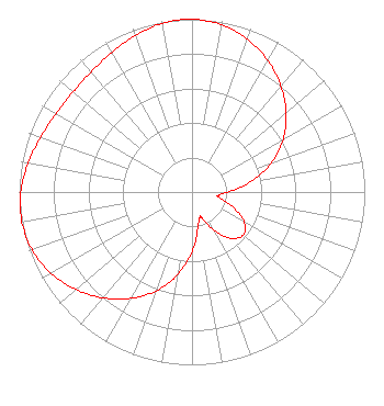 | ||||||||||||||||||
| Azimuth | Ratio | Azimuth | Ratio | Azimuth | Ratio | Azimuth | Ratio | ||||||||||||
| 0 | 1.000 | 10 | 0.983 | 20 | 0.941 | 30 | 0.878 | ||||||||||||
| 40 | 0.800 | 50 | 0.711 | 60 | 0.609 | 70 | 0.488 | ||||||||||||
| 80 | 0.347 | 90 | 0.206 | 98 | 0.151 | 100 | 0.156 | ||||||||||||
| 110 | 0.252 | 120 | 0.349 | 130 | 0.387 | 140 | 0.349 | ||||||||||||
| 150 | 0.252 | 160 | 0.156 | 162 | 0.151 | 170 | 0.206 | ||||||||||||
| 180 | 0.347 | 190 | 0.488 | 200 | 0.609 | 210 | 0.711 | ||||||||||||
| 220 | 0.800 | 230 | 0.878 | 240 | 0.941 | 250 | 0.983 | ||||||||||||
| 260 | 1.000 | 262 | 1.000 | 270 | 0.991 | 280 | 0.963 | ||||||||||||
| 290 | 0.931 | 300 | 0.908 | 310 | 0.899 | 320 | 0.908 | ||||||||||||
| 330 | 0.931 | 340 | 0.963 | 350 | 0.991 | 358 | 1.000 | ||||||||||||
Structure Registration Number 1006574 Structure Type: LTOWER Registered To: Cellco Partnership Structure Address: 1267 Winchester Rd Sedalia, MO County Name: Pettis County ASR Issued: 06/14/2017 Date Built: 11/01/2006 Site Elevation: 264.9 m (869 ft.) Structure Height: 86.9 m (285 ft.) Height Overall: 91.5 m (300 ft.) Overall Height AMSL: 356.4 m (1169 ft.) FAA Determination: 11/02/2015 FAA Study #: 2015-ACE-3710-OE FAA Circular #: 70/7460-1K Paint & Light FAA Chapters: 4, 6, 12 OM&L to remain the same as prior study = 24-HR MED-STROBES 38-42-07.4 N 93-16-47.9 W (NAD 83) 38-42-07.3 N 93-16-47.2 W (Converted to NAD 27) |
Hurst, TX 76054 Phone: 214-770-7770 Corporation | Title: Ceo Date: 03/16/2023 Application Certifier EDGE SPECTRUM, INC. Edge Spectrum, Inc. Hurst, TX 76054 Applicant Susan Hansen B. W. St. Clair 2305 Vida Shaw Rd. New Iberia, LA 70563 Consultant Ari Meltzer Wiley Rein Llp 2050 M Street, Nw Washington, DC 20036 Josh Weiss Ark Multicasting, Inc. Cedar Hill, TX 75104 CEO Caleb Weiss Ark Multicasting, Inc. Cedar Hill, TX 75106 President Randy Weiss Edge Spectrum, Inc. Hurst, TX 76054 CEO | |||||||||||||||||