
FCCInfo.com
A Service of Cavell, Mertz & Associates, Inc.
(855) FCC-INFO
|
|
W35ED-D from 02/22/2011 |
|
|
|||||||||||||||||
|
|
Status: License Application Accepted: 05/23/2023 License Expires: 12/01/2028 File Number: -0000215078 FCC Website Links: LMS Facility Details This Application Other W35ED-D Applications Including Superseded Applications Mailing Address Correspondence for W35ED-D Correspondence related to application -0000215078 Service Contour - Open Street Map or USGS Map (51 dBu) Service Contour - KML / Google Earth (51 dBu) Rabbit Ears Info Search for W35ED-D Site Location: 34-16-48.1 N 79-44-34.4 W (NAD 83) Site Location: 34-16-47.5 N 79-44-35.2 W (Converted to NAD 27) ERP: 15 kW Polarization: Elliptically polarized Electrical Beam Tilt: 1.0 degree R/C AGL: 222.5 m (730 ft.) R/C AMSL: 259 m (850 ft.) Emission Mask: Full Service Site Elevation: 36.5 m. (120 ft.) Height Overall*: 246.7 m (809 ft.) (* As Filed In This Application, may differ from ASR Data, Below.) Directional Antenna - Antenna Make/Model: DIELECTRIC DLP-12B/VP Antenna ID: 1010736 Polarization: Elliptically polarized
| |||||||||||||||||||
| Antenna Data for Antenna Id: 1010736 W35ED-D LD File: -0000215078 DIELECTRIC - DLP-12B/VP Service: LD Standard Pattern: N Pattern and Field Values Include a 220° Clockwise Rotation | 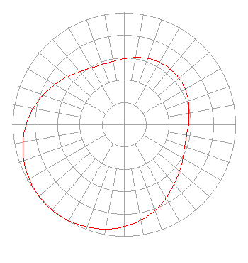 | |||||||||||||||||||
| Azimuth | Ratio | Azimuth | Ratio | Azimuth | Ratio | Azimuth | Ratio | |||||||||||||
| 0 | 0.586 | 10 | 0.607 | 20 | 0.627 | 30 | 0.640 | |||||||||||||
| 40 | 0.645 | 50 | 0.641 | 60 | 0.631 | 70 | 0.613 | |||||||||||||
| 80 | 0.592 | 90 | 0.579 | 100 | 0.570 | 110 | 0.579 | |||||||||||||
| 120 | 0.610 | 130 | 0.650 | 140 | 0.699 | 150 | 0.759 | |||||||||||||
| 160 | 0.817 | 170 | 0.869 | 180 | 0.914 | 190 | 0.951 | |||||||||||||
| 200 | 0.975 | 210 | 0.993 | 220 | 1.000 | 230 | 0.996 | |||||||||||||
| 240 | 0.981 | 250 | 0.955 | 260 | 0.920 | 270 | 0.876 | |||||||||||||
| 280 | 0.826 | 290 | 0.771 | 300 | 0.714 | 310 | 0.661 | |||||||||||||
| 320 | 0.615 | 330 | 0.583 | 340 | 0.569 | 350 | 0.571 | |||||||||||||
Structure Registration Number 1059180 Structure Type: TOWER Registered To: South Carolina Educational TV Commission Structure Address: County Road 173, 5.5 Mi Nne Florence, SC County Name: Darlington County ASR Issued: 08/24/2018 Date Built: 01/27/2005 Site Elevation: 36.5 m (120 ft.) Structure Height: 228.9 m (751 ft.) Height Overall: 246.7 m (809 ft.) Overall Height AMSL: 283.2 m (929 ft.) FAA Determination: 08/05/2004 FAA Study #: 2004-ASO-3892-OE FAA Circular #: 70/7460-1K Paint & Light FAA Chapters: 3, 4, 5, 12 Removed expiration date from determination. Scenario 1./jjs/case#635066 34-16-48.1 N 79-44-34.4 W (NAD 83) 34-16-47.5 N 79-44-35.2 W (Converted to NAD 27) |
4370 Peachtree Road, Ne Atlanta, GA 30319 Phone: 202-750-1585 Limited Liability Company | Title: Assistant Secretary Date: 05/23/2023 Application Certifier Gray Television Licensee, Llc 4370 Peachtree Road, Ne Atlanta, GA 30319 Applicant Joseph M. Davis, P.E. Chesapeake Rf Consultants, Llc 207 Old Dominion Road Yorktown, VA 23692 Consulting Engineer Joan Stewart Wiley Rein Llp 2050 M Street Nw Washington, DC 20036 | ||||||||||||||||||