
FCCInfo.com
A Service of Cavell, Mertz & Associates, Inc.
(855) FCC-INFO
|
|
W22FN-D from 07/11/2012 |
|
|
|||||||||||||||||||||||
|
|
Status: License Application Accepted: 06/06/2023 License Expires: 12/01/2028 File Number: -0000216271 FCC Website Links: LMS Facility Details This Application Other W22FN-D Applications Including Superseded Applications Mailing Address Correspondence for W22FN-D Correspondence related to application -0000216271 Service Contour - Open Street Map or USGS Map (51 dBu) Service Contour - KML / Google Earth (51 dBu) Rabbit Ears Info Search for W22FN-D Site Location: 34-11-27.3 N 77-56-31.2 W (NAD 83) Site Location: 34-11-26.7 N 77-56-32.2 W (Converted to NAD 27) ERP: 15 kW Polarization: Horizontally polarized Electrical Beam Tilt: 1 degree R/C AGL: 61 m (200 ft.) R/C AMSL: 74.4 m (244 ft.) Emission Mask: Stringent Site Elevation: 13.4 m. (44 ft.) Height Overall*: 92.6 m (304 ft.) (* As Filed In This Application, may differ from ASR Data, Below.) Directional Antenna - Antenna Make/Model: Propagation System Inc PSILP8BB Antenna ID: 20484 Polarization: Horizontally polarized
| |||||||||||||||||||||||||
| Antenna Data for Antenna Id: 20484 W22FN-D LD File: -0000216271 Propagation System Inc - PSILP8BB Service: LD Standard Pattern: Y Pattern and Field Values Include a 290° Clockwise Rotation | 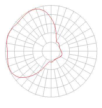 | |||||||||||||||||||||||||
| Azimuth | Ratio | Azimuth | Ratio | Azimuth | Ratio | Azimuth | Ratio | |||||||||||||||||||
| 0 | 0.720 | 10 | 0.520 | 20 | 0.330 | 30 | 0.240 | |||||||||||||||||||
| 40 | 0.240 | 50 | 0.230 | 60 | 0.210 | 70 | 0.200 | |||||||||||||||||||
| 80 | 0.210 | 90 | 0.220 | 100 | 0.240 | 110 | 0.250 | |||||||||||||||||||
| 120 | 0.240 | 130 | 0.220 | 140 | 0.210 | 150 | 0.200 | |||||||||||||||||||
| 160 | 0.210 | 170 | 0.230 | 180 | 0.240 | 190 | 0.240 | |||||||||||||||||||
| 200 | 0.330 | 210 | 0.520 | 220 | 0.720 | 230 | 0.890 | |||||||||||||||||||
| 240 | 0.970 | 250 | 0.980 | 260 | 0.960 | 270 | 0.950 | |||||||||||||||||||
| 280 | 0.980 | 290 | 1.000 | 300 | 0.980 | 310 | 0.950 | |||||||||||||||||||
| 320 | 0.960 | 330 | 0.980 | 340 | 0.970 | 350 | 0.890 | |||||||||||||||||||
Structure Registration Number 1006714 Structure Type: GTOWER Registered To: Gray Media Group, Inc. Structure Address: 322 Shipyard Blvd Wilmington, NC County Name: New Hanover County ASR Issued: 02/11/2019 Date Built: 08/13/2012 Site Elevation: 13.4 m (44 ft.) Structure Height: 91.4 m (300 ft.) Height Overall: 92.6 m (304 ft.) Overall Height AMSL: 106 m (348 ft.) FAA Determination: 08/10/2012 FAA Study #: 2012-ASO-7488-OE Paint & Light FAA Chapters: 1, 3, 11, 21 PRIOR STUDY 1991-ASO-486-OE 34-11-27.3 N 77-56-31.2 W (NAD 83) 34-11-26.7 N 77-56-32.2 W (Converted to NAD 27) |
14 Tuxedo Drive Beaufort, SC 29907 Phone: 717-226-3535 Limited Liability Company | Title: Managing Member Date: 06/06/2023 Application Certifier Lowcountry 34 Media, Llc 14 Tuxedo Drive Beaufort, SC 29907 Applicant Darryl K DeLawder Delawder Communications, Inc. P. O. Box 1095 Ashburn, VA 20146 President Davina Sashkin, Esq Wilkinson Barker Knauer, Llp 1800 M Street, Nw Suite 800n Washington, DC 20036 | ||||||||||||||||||||||||