
FCCInfo.com
A Service of Cavell, Mertz & Associates, Inc.
(855) FCC-INFO
|
|
|
|
|
||||||||||||||||
|
|
Status: License Application Accepted: 06/08/2023 License Expires: 12/02/2030 File Number: -0000216441 FCC Website Links: LMS Facility Details This Application Other K11XS-D Applications Including Superseded Applications Mailing Address Correspondence for K11XS-D Correspondence related to application -0000216441 Service Contour - Open Street Map or USGS Map (48 dBu) Service Contour - KML / Google Earth (48 dBu) Rabbit Ears Info Search for K11XS-D Site Location: 37-53-55.4 N 121-06-36.1 W (NAD 83) Site Location: 37-53-55.7 N 121-06-32.3 W (Converted to NAD 27) ERP: 3 kW Polarization: Horizontally polarized Electrical Beam Tilt: 0.5 degrees R/C AGL: 60 m (197 ft.) R/C AMSL: 80.7 m (265 ft.) Emission Mask: Full Service Site Elevation: 20.7 m. (68 ft.) Height Overall*: 79.2 m (260 ft.) (* As Filed In This Application, may differ from ASR Data, Below.) Directional Antenna - Antenna Make/Model: MICRO COMMUNICATIONS INC AT11-220 Antenna ID: 93465 Polarization: Horizontally polarized | ||||||||||||||||||
| Antenna Data for Antenna Id: 93465 K11XS-D LD File: -0000216441 MICRO COMMUNICATIONS INC - AT11-220 Service: LD Standard Pattern: Y Pattern and Field Values Include a 155° Clockwise Rotation | 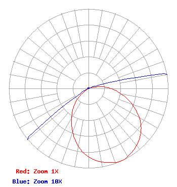 | ||||||||||||||||||
| Azimuth | Ratio | Azimuth | Ratio | Azimuth | Ratio | Azimuth | Ratio | ||||||||||||
| 5 | 0.001 | 15 | 0.001 | 25 | 0.001 | 35 | 0.001 | ||||||||||||
| 45 | 0.001 | 55 | 0.001 | 65 | 0.001 | 75 | 0.036 | ||||||||||||
| 85 | 0.211 | 95 | 0.351 | 105 | 0.501 | 115 | 0.661 | ||||||||||||
| 125 | 0.804 | 135 | 0.902 | 145 | 0.966 | 155 | 1.000 | ||||||||||||
| 165 | 0.966 | 175 | 0.902 | 185 | 0.804 | 195 | 0.661 | ||||||||||||
| 205 | 0.501 | 215 | 0.351 | 225 | 0.211 | 235 | 0.036 | ||||||||||||
| 245 | 0.001 | 255 | 0.001 | 265 | 0.001 | 275 | 0.001 | ||||||||||||
| 285 | 0.001 | 295 | 0.001 | 305 | 0.001 | 315 | 0.001 | ||||||||||||
| 325 | 0.001 | 335 | 0.001 | 345 | 0.001 | 355 | 0.001 | ||||||||||||
Structure Registration Number 1026312 Structure Type: TOWER Registered To: American Towers LLC Structure Address: Off Of Sola Road (collegeville #89308) Stockton, CA County Name: San Joaquin County ASR Issued: 01/15/2013 Date Built: 01/01/1997 Site Elevation: 20.7 m (68 ft.) Structure Height: 76.2 m (250 ft.) Height Overall: 79.2 m (260 ft.) Overall Height AMSL: 99.9 m (328 ft.) FAA Determination: 08/17/2004 FAA Study #: 2004-AWP-3755-OE FAA Circular #: 70/7460-1J Paint & Light FAA Chapters: 4, 6, 13 OM&L to remain the same as prior study = 24-HR MED-STROBES 37-53-55.4 N 121-06-36.1 W (NAD 83) 37-53-55.7 N 121-06-32.3 W (Converted to NAD 27) |
2383 Pruneridge Avenue Suite 4 Santa Clara, CA 95050 Phone: 415-886-7284 Corporation | Title: President Date: 06/08/2023 Application Certifier Major Market Broadcasting Of California, Inc. 2383 Pruneridge Avenue Suite 4 Santa Clara, CA 95050 Applicant Davina S Sashkin, Esq Baker & Hostetler Llp 1050 Connecticut Avenue, Nw Suite 1100 Washington, DC 20036 | |||||||||||||||||