
FCCInfo.com
A Service of Cavell, Mertz & Associates, Inc.
(855) FCC-INFO
|
|
|
|
|
||||||||||||||||
|
|
Status: Construction Permit Application Accepted: 07/31/2023 W19DW-D CP Expires: 08/01/2026 File Number: -0000218654 FCC Website Links: LMS Facility Details This Application Other W19DW-D Applications Including Superseded Applications Mailing Address Correspondence for W19DW-D Correspondence related to application -0000218654 Service Contour - Open Street Map or USGS Map (51 dBu) Service Contour - KML / Google Earth (51 dBu) Rabbit Ears Info Search for W19DW-D Site Location: 32-27-29.0 N 84-53-08.0 W (NAD 83) Site Location: 32-27-28.5 N 84-53-08.3 W (Converted to NAD 27) ERP: 15 kW Polarization: Horizontally polarized Electrical Beam Tilt: 1 degree R/C AGL: 85.3 m (280 ft.) R/C AMSL: 202.6 m (665 ft.) Emission Mask: Stringent Site Elevation: 117.3 m. (385 ft.) Height Overall*: 400.9 m (1315 ft.) (* As Filed In This Application, may differ from ASR Data, Below.) Directional Antenna - Antenna Make/Model: Propagation System Inc PSILP8AER Antenna ID: 20469 Polarization: Horizontally polarized
| ||||||||||||||||||
| Antenna Data for Antenna Id: 20469 W19DW-D LD File: -0000218654 Propagation System Inc - PSILP8AER Service: LD Standard Pattern: Y Pattern and Field Values Include a 90° Clockwise Rotation | 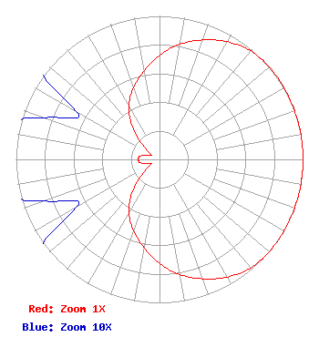 | ||||||||||||||||||
| Azimuth | Ratio | Azimuth | Ratio | Azimuth | Ratio | Azimuth | Ratio | ||||||||||||
| 0 | 0.725 | 10 | 0.815 | 20 | 0.886 | 30 | 0.946 | ||||||||||||
| 40 | 0.988 | 50 | 1.000 | 60 | 1.000 | 70 | 1.000 | ||||||||||||
| 80 | 1.000 | 90 | 1.000 | 100 | 1.000 | 110 | 1.000 | ||||||||||||
| 120 | 1.000 | 130 | 1.000 | 140 | 0.988 | 150 | 0.946 | ||||||||||||
| 160 | 0.886 | 170 | 0.815 | 180 | 0.725 | 190 | 0.624 | ||||||||||||
| 200 | 0.529 | 210 | 0.428 | 220 | 0.293 | 230 | 0.146 | ||||||||||||
| 240 | 0.067 | 250 | 0.085 | 260 | 0.136 | 270 | 0.147 | ||||||||||||
| 280 | 0.136 | 290 | 0.085 | 300 | 0.067 | 310 | 0.146 | ||||||||||||
| 320 | 0.293 | 330 | 0.428 | 340 | 0.529 | 350 | 0.624 | ||||||||||||
Structure Registration Number 1032658 Structure Type: TOWER Registered To: Gray Media Group, Inc. Structure Address: 6140 Buena Vista Road Columbus, GA County Name: Muscogee County ASR Issued: 12/28/2020 Date Built: 09/23/1982 Site Elevation: 117.3 m (385 ft.) Structure Height: 381.8 m (1253 ft.) Height Overall: 400.9 m (1315 ft.) Overall Height AMSL: 518.2 m (1700 ft.) FAA Determination: 08/01/1997 FAA Study #: 97-ASO-3017-OE FAA Circular #: 70/7460-1J Paint & Light FAA Chapters: 3, 4, 5, 13 32-27-29.0 N 84-53-08.0 W (NAD 83) 32-27-28.5 N 84-53-08.3 W (Converted to NAD 27) |
14 Tuxedo Drive Beaufort, SC 29907 Phone: 717-226-3535 Limited Liability Company | Title: Manager Date: 07/31/2023 Application Certifier Lowcountry 34 Media, Llc 14 Tuxedo Drive Beaufort, SC 29907 Applicant Darryl K DeLawder Delawder Communications, Inc. P.o. Box 1095 Ashburn, VA 20146 President Davina Sashkin, Esq Wilkinson Barker Knauer, Llp 1800 M Street, Nw Suite 800n Washington, DC 20036 | |||||||||||||||||