
FCCInfo.com
A Service of Cavell, Mertz & Associates, Inc.
(855) FCC-INFO
|
|
WIVD-LD from 02/10/2009 WIVD-LD from 01/28/2009 WIVD-LD from 06/29/2006 |
|
|
||||||||||||||||
|
|
Status: Application Application Accepted: 12/21/2023 License Expires: 10/01/2029 File Number: -0000233536 FCC Website Links: LMS Facility Details This Application Other WIVD-LD Applications Including Superseded Applications Mailing Address Correspondence for WIVD-LD Correspondence related to application -0000233536 Service Contour - Open Street Map or USGS Map (51 dBu) Service Contour - KML / Google Earth (51 dBu) Rabbit Ears Info Search for WIVD-LD Site Location: 40-53-55.0 N 81-12-36.0 W (NAD 83) Site Location: 40-53-54.8 N 81-12-36.6 W (Converted to NAD 27) ERP: 15 kW Polarization: Elliptically polarized Electrical Beam Tilt: 0.5 degrees R/C AGL: 87.2 m (286 ft.) R/C AMSL: 469.2 m (1539 ft.) Emission Mask: Full Service Site Elevation: 382 m. (1253 ft.) Height Overall*: 91.7 m (301 ft.) (* As Filed In This Application, may differ from ASR Data, Below.) Directional Antenna - Antenna Make/Model: Propagation System Inc PSI UHF Slot Antenna ID: 1005363 Polarization: Elliptically polarized
| ||||||||||||||||||
| Antenna Data for Antenna Id: 1005363 WIVD-LD LD File: -0000233536 Propagation System Inc - PSI UHF Slot Service: LD Standard Pattern: Y Pattern and Field Values Include a 215° Clockwise Rotation | 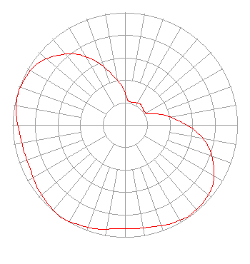 | ||||||||||||||||||
| Azimuth | Ratio | Azimuth | Ratio | Azimuth | Ratio | Azimuth | Ratio | ||||||||||||
| 5 | 0.229 | 15 | 0.209 | 25 | 0.219 | 35 | 0.229 | ||||||||||||
| 45 | 0.219 | 55 | 0.209 | 65 | 0.229 | 75 | 0.349 | ||||||||||||
| 85 | 0.469 | 95 | 0.629 | 105 | 0.769 | 115 | 0.869 | ||||||||||||
| 125 | 0.949 | 135 | 0.979 | 145 | 0.989 | 155 | 0.969 | ||||||||||||
| 165 | 0.939 | 175 | 0.929 | 185 | 0.929 | 195 | 0.959 | ||||||||||||
| 205 | 0.979 | 215 | 1.000 | 225 | 0.979 | 235 | 0.959 | ||||||||||||
| 245 | 0.929 | 255 | 0.929 | 265 | 0.939 | 275 | 0.969 | ||||||||||||
| 285 | 0.989 | 295 | 0.979 | 305 | 0.949 | 315 | 0.869 | ||||||||||||
| 325 | 0.769 | 335 | 0.629 | 345 | 0.469 | 355 | 0.349 | ||||||||||||
Structure Registration Number 1050165 Structure Type: TOWER Registered To: IMAGE VIDEO TELEPRODUCTIONS, INC. Structure Address: 1 Mi At Azimuth 68 Deg. Harrisburg, OH County Name: Stark County ASR Issued: 03/23/2009 Date Built: 06/24/1997 Site Elevation: 382 m (1253 ft.) Structure Height: 91.7 m (301 ft.) Height Overall: 91.7 m (301 ft.) Overall Height AMSL: 473.7 m (1554 ft.) FAA Determination: 01/14/1997 FAA Study #: 96-AGL-4261-OE FAA Circular #: 70/7460-1J Paint & Light FAA Chapters: 4, 6, 13 40-53-55.0 N 81-12-36.0 W (NAD 83) 40-53-54.8 N 81-12-36.6 W (Converted to NAD 27) |
6755 Freedom Ave., N.w. North Canton, OH 44720 Phone: 330-494-9303 Corporation | Title: President Date: 12/21/2023 Application Certifier IMAGE VIDEO TELEPRODUCTIONS, INC. Image Video Teleproductions, Inc. 6755 Freedom Ave., N.w. North Canton, OH 44720 Applicant Darryl K DeLawder Delawder Communications, Inc. P. O. Box 1095 Ashburn, VA 20146 President Kathleen Victory Fletcher, Heald & Hildreth, P.l.c. 1300 N. 17th Street 11th Floor Arlington, VA 22209 FCC Counsel | |||||||||||||||||