
FCCInfo.com
A Service of Cavell, Mertz & Associates, Inc.
(855) FCC-INFO
|
|
W13DS-D from 06/02/2020 W13DS-D from 01/26/2020 W13DS-D from 04/21/1997 W13DS-D from 02/03/1998 W13DS-D from 08/12/1986 |
|
|
|||||||||||||||||
|
|
Status: Application Application Accepted: 01/19/2024 License Expires: 00/00/0000 File Number: -0000235233 FCC Website Links: LMS Facility Details This Application Other W13DS-D Applications Including Superseded Applications Mailing Address Correspondence for W13DS-D Correspondence related to application -0000235233 Service Contour - Open Street Map or USGS Map (48 dBu) Service Contour - KML / Google Earth (48 dBu) Rabbit Ears Info Search for W13DS-D Site Location: 41-31-40.8 N 81-05-05.5 W (NAD 83) Site Location: 41-31-40.6 N 81-05-06.1 W (Converted to NAD 27) ERP: 3 kW Polarization: Horizontally polarized R/C AGL: 62 m (203 ft.) R/C AMSL: 458.2 m (1503 ft.) Emission Mask: Full Service Site Elevation: 396.2 m. (1300 ft.) Height Overall*: 95.4 m (313 ft.) (* As Filed In This Application, may differ from ASR Data, Below.) Directional Antenna - Antenna Make/Model: DIELECTRIC THA-MC2 Antenna ID: 38092 Polarization: Horizontally polarized
| |||||||||||||||||||
| Antenna Data for Antenna Id: 38092 W13DS-D LD File: -0000235233 DIELECTRIC - THA-MC2 Service: LD Standard Pattern: Y Pattern and Field Values Include a 289.0° Clockwise Rotation | 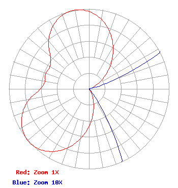 | |||||||||||||||||||
| Azimuth | Ratio | Azimuth | Ratio | Azimuth | Ratio | Azimuth | Ratio | |||||||||||||
| 9 | 0.894 | 19 | 0.772 | 29 | 0.619 | 39 | 0.451 | |||||||||||||
| 49 | 0.287 | 59 | 0.145 | 69 | 0.043 | 79 | 0.001 | |||||||||||||
| 89 | 0.001 | 99 | 0.001 | 109 | 0.001 | 119 | 0.001 | |||||||||||||
| 129 | 0.001 | 139 | 0.001 | 149 | 0.043 | 159 | 0.145 | |||||||||||||
| 169 | 0.287 | 179 | 0.451 | 189 | 0.619 | 199 | 0.772 | |||||||||||||
| 209 | 0.894 | 219 | 0.973 | 229 | 1.000 | 239 | 0.973 | |||||||||||||
| 249 | 0.894 | 259 | 0.772 | 269 | 0.617 | 279 | 0.559 | |||||||||||||
| 289 | 0.574 | 299 | 0.559 | 309 | 0.617 | 319 | 0.772 | |||||||||||||
| 329 | 0.894 | 339 | 0.973 | 349 | 1.000 | 359 | 0.973 | |||||||||||||
Structure Registration Number 1013753 Structure Type: GTOWER Registered To: American Towers LLC Structure Address: 12603 Princeton Rd (huntsburg #90107) Huntsburg, OH County Name: Geauga County ASR Issued: 10/26/2022 Date Built: 04/18/2001 Site Elevation: 396.2 m (1300 ft.) Structure Height: 94.8 m (311 ft.) Height Overall: 95.4 m (313 ft.) Overall Height AMSL: 491.6 m (1613 ft.) FAA Determination: 10/17/2022 FAA Study #: 2021-AGL-27982-OE FAA Circular #: 70/7460-1J Paint & Light FAA Chapters: 4, 8, 13 OM&L to remain the same as prior study = A MED-DUAL SYSTEM 41-31-40.8 N 81-05-05.5 W (NAD 83) 41-31-40.6 N 81-05-06.1 W (Converted to NAD 27) |
Po Box 11409 Chattanooga, TN 37401 Phone: 423-468-5100 Applicant | Title: Coo Date: 01/19/2024 Application Certifier DIGITAL NETWORKS-NORTHEAST, LLC Digital Networks-northeast, Llc Po Box 11409 Chattanooga, TN 37401 Applicant Aaron P Shainis Shainis & Peltzman, Chartered 1850 M St. Nw Suite 240 Washington, DC 20036 FCC Legal Counsel Timothy Z Sawyer T Z Sawyer Technical Consultants 2130 Hutchison Grove Court Suite 100 Falls Church, VA 22043 Technical Consultant | ||||||||||||||||||