
FCCInfo.com
A Service of Cavell, Mertz & Associates, Inc.
(855) FCC-INFO
|
|
|
|
|
||||||||||||||||
|
|
Status: Construction Permit Application Accepted: 03/06/2024 WQEK-LD CP Expires: 03/08/2027 File Number: -0000240467 FCC Website Links: LMS Facility Details This Application Other WQEK-LD Applications Including Superseded Applications Mailing Address Correspondence for WQEK-LD Correspondence related to application -0000240467 Service Contour - Open Street Map or USGS Map (51 dBu) Service Contour - KML / Google Earth (51 dBu) Rabbit Ears Info Search for WQEK-LD Site Location: 35-16-33.0 N 89-46-38.0 W (NAD 83) Site Location: 35-16-32.7 N 89-46-37.7 W (Converted to NAD 27) ERP: 10 kW Polarization: Horizontally polarized Electrical Beam Tilt: 0.75 degrees R/C AGL: 350 m (1148 ft.) R/C AMSL: 426.2 m (1398 ft.) Emission Mask: Full Service Site Elevation: 76.2 m. (250 ft.) Height Overall*: 365.4 m (1199 ft.) (* As Filed In This Application, may differ from ASR Data, Below.) Directional Antenna - Antenna Make/Model: Propagation System Inc PSILP8NC Antenna ID: 20498 Polarization: Horizontally polarized | ||||||||||||||||||
| Antenna Data for Antenna Id: 20498 WQEK-LD LD File: -0000240467 Propagation System Inc - PSILP8NC Service: LD Standard Pattern: Y Pattern and Field Values Include a 235° Clockwise Rotation | 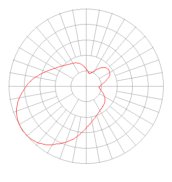 | ||||||||||||||||||
| Azimuth | Ratio | Azimuth | Ratio | Azimuth | Ratio | Azimuth | Ratio | ||||||||||||
| 5 | 0.200 | 15 | 0.170 | 25 | 0.200 | 35 | 0.270 | ||||||||||||
| 45 | 0.340 | 55 | 0.360 | 65 | 0.340 | 75 | 0.270 | ||||||||||||
| 85 | 0.200 | 95 | 0.170 | 105 | 0.200 | 115 | 0.250 | ||||||||||||
| 125 | 0.300 | 135 | 0.330 | 145 | 0.350 | 155 | 0.380 | ||||||||||||
| 165 | 0.430 | 175 | 0.500 | 185 | 0.600 | 195 | 0.720 | ||||||||||||
| 205 | 0.820 | 215 | 0.920 | 225 | 0.980 | 235 | 1.000 | ||||||||||||
| 245 | 0.980 | 255 | 0.920 | 265 | 0.820 | 275 | 0.720 | ||||||||||||
| 285 | 0.600 | 295 | 0.500 | 305 | 0.430 | 315 | 0.380 | ||||||||||||
| 325 | 0.350 | 335 | 0.330 | 345 | 0.300 | 355 | 0.250 | ||||||||||||
Structure Registration Number 1057943 Structure Type: TOWER Registered To: Vertical Bridge CC FM, LLC Structure Address: 5205 Brief Rd. Brunswick, TN County Name: Shelby County ASR Issued: 12/19/2018 Date Built: 05/16/1999 Site Elevation: 76.2 m (250 ft.) Structure Height: 364.5 m (1196 ft.) Height Overall: 365.4 m (1199 ft.) Overall Height AMSL: 441.6 m (1449 ft.) FAA Determination: 04/29/1998 FAA Study #: 97-ASO-5606-OE FAA Circular #: 70/7460-1J Paint & Light FAA Chapters: 4, 7, 13 SUPPLEMENTAL NOTICE DATED 5-16-99 SHOWS REACHED GRTST HT 5-15-99. 35-16-33.0 N 89-46-38.0 W (NAD 83) 35-16-32.7 N 89-46-37.7 W (Converted to NAD 27) |
295 Madison Avenue, 12th Floor New York, NY 10017 Phone: 954-606-5486 Corporation | Title: Vice President Of Regulatory Affairs Date: 03/06/2024 Application Certifier Dtv America Corporation 295 Madison Avenue, 12th Floor New York, NY 10017 Applicant MICHAEL VOGE Hc2 Broadcasting Holdings, Inc. 295 Madison Avenue, 12th Floor New York, NY 10017 DIRECTOR OF ENGINEERING OPERATIONS RENEE ILHARDT Hc2 Broadcasting Holdings, Inc. 295 Madison Avenue, 12th Floor New York, NY 10017 VP, REGULATORY AFFAIRS DAVID O'CONNOR Wilkinson, Barker, Knauer, Llp 1800 M Street, Nw; Suite 800n Washington, DC 20036 PARTNER | |||||||||||||||||